Orrest Head & Allen Knott from Windermere
Lake District Walk
Nat Park - Lake District - Lake District Lesser Fells
County/Area - Cumbria
Author - Lou Johnson
Length - 4.4 miles / 7.2 km Ascent - 600 feet / 182 metres
Time - 2 hours 50 minutes Grade - easy
Walk Route Description
Click image to see photo description.
This Lake District walk from Windermere first visits the superb viewpoint of Orrest Head, which inspired Alfred Wainwright to investigate Lakeland in greater detail, and continues north past Allen Knott before turning south via Howe Hill and Elleray Bank to return to the start.
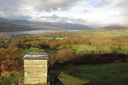
The start is the Tourist Office by Windermere Railway station (grid ref. SD413987). Cross the A591 and turn left towards Ambleside. Turn right into Tuchwud (just before the green metal railings) and bear left to reach a 'Footpath to Orrest Head' sign with an arrow pointing the way. The sign suggests 20 minutes to the summit, which for some is very optimistic! Follow the lane up through trees to pass a farm. Shortly after take the right-hand path (with wall on your right) and continue to a cross wall. Turn right into a fenced lane and after 200 metres turn left through a kissing gate which gives access via steps to the summit of Orrest Head.
There is a topograph showing the main points on interest and it is worth spending some time here to enjoy the magnificent panorama. Personally, it was wonderful to see many of the fells I had climbed on previous walks and also to see how the topography fitted together. To continue, head north on a twisting descending path to a wall junction (grid ref. SD414995). Continue straight ahead, ignoring the path to the left. Maintain direction for 600 metres on a distinct path which roughly parallels the wall to your left. This path leads to a metal gate and a lane (grid ref. SD417000).
Turn right along the lane and continue to the first footpath on the left signed to 'Far Orrest'. Cross the stile and follow the path which curves around Near Orrest Farm on your right. The path then heads to the right-hand end of a bank of trees before heading straight across a field. Continue for 200 metres with the wall on your right before crossing another field aiming for the trees on the other side. Continue through the next field with the wall on your left to reach a track with Far Orrest Farm on your left (grid ref. NY414007). Keep the farm buildings on your left, ignore the path left and keep ahead to join a walled track. This leads north passing Allen Knott on your right. The route continues north through a gate and across a field to reach Moorhouse Road (grid ref. NY414013).
Turn left along Moorhouse Road. Ahead you have views to Lake Windermere. Where the road forks, take the smaller lane to the left (Dodd's Lane). The lane descends quite steeply. Turn left onto a driveway just before a green salt hopper (waymark on the wall to your left). Continue past some houses on your left and where the driveway forks, bear left. Follow the drive to reach Far Orrest Farm. Follow the waymarks through the farm and head following a farm track alongside a wall on your left. This track is easy to follow and after 800 metres you reach a lane by Crosses Farm (grid ref. NY411000).
Turn left and you soon reach a kissing gate and footpath sign on the right. Take this path into the woods. On leaving the woods bears left alongside a wall (on your left) to reach a wall. From here proceed half right across the field to the far-right hand corner where you join a track at Elleray Bank (grid ref. SD412993). Take the right-hand track and continue to a T-junction. Turn left and follow the lane back to the start.
Maps 

| Ordnance Survey Explorer OL7 | Sheet Map | 1:25k | BUY |
| Anquet OS Explorer OL7 | Digital Map | 1:25k | BUY |
| Ordnance Survey Digital Map Subscription | |||
| Latest Ordnance Survey Discounts | |||
Other walks nearby
| Walk 1463 | School Knott & Grandsire from Ings | easy/mod | 6.5 miles |
| Walk 2053 | Claife Heights & Near Sawrey | easy | 2.5 miles |
| Walk 1555 | Brunt Knott from Staveley | easy/mod | 7.0 miles |
| Walk 2464 | Kentmere Valley Circular | moderate | 10.0 miles |
| Walk 1049 | Staveley Tarns circular | easy/mod | 6.0 miles |
| Walk 3410 | Latterbarrow from Hawkshead | easy | 4.0 miles |
| Walk 1002 | The Fairfield Horseshoe | mod/hard | 11.0 miles |
| Walk 1170 | Fairfield Horseshoe (short route) | mod/hard | 9.5 miles |
| Walk 1023 | Wansfell Pike & Wansfell | easy/mod | 7.5 miles |
| Walk 3519 | High Sweden Bridge | easy/mod | 3.0 miles |
Recommended Books & eBooks
Walking the Lake District Fells - Wasdale
 Part of the Walking the Lake District Fells series, this guidebook covers a wide range of routes to 25 Lakeland summits that can be climbed from the Wasdale, Eskdale and Ennerdale valleys, with highlights including Scafell Pike, Great Gable and Pillar. Suggestions for longer ridge routes are also included.
More information
Outdoor Adventures with Children - Lake District
 Guidebook to 40 outdoor adventures in the Lake District with children under 12, including walking, cycling, orienteering, paddling, boating, hostelling and more. Graded activities for varying age ranges or for families with children of different ages.
More information
