Walk 3465 - printer friendly version
Foel Eryr Circular, Preseli Hills Walk
Author - Lou Johnson
Length - 6.0 miles / 9.8 km
Ascent - 1000 feet / 303 metres
Grade - moderate
Start - OS grid reference SN075322
Lat 51.9548820 + Long -4.8028356
Postcode SA66 7RB (approx. location only)
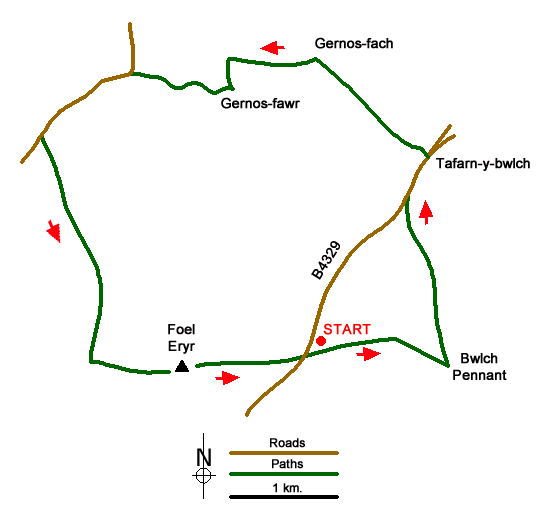
Foel Eryr is the westernmost summit on the Preseli Hills ridge. The hill can be easily climbed from the B4329, but this circular route explores the countryside lying to the north. The walk follows bridleways, lanes, and paths. On some sections of the route the paths are intermittent, so a good sense of direction is required.
The start is the car park lying on the col east of Foel Eryr on the B4329 (grid ref. SN075322). After parking leave the rear of the parking area to follow a good path east. The path climbs gently with a plantation to your right before descending to the col of Bwlch Pennant (grid ref. 085321). Turn left here and follow the bridleway north and then north-north-west to re-join the B4329 after 1.5 kilometres of downhill walking (grid ref. SN082333).
Turn right along the road and continue downhill to reach a gate across the road. Turn left onto a track. Pass through the gate and continue to Gernos-fach (grid ref. SN075343). Turn left and pass between the house and farm buildings following a clear track. After 700 metres turn left down an enclosed track and continue to Gernos-fawr. Pass through the buildings and continue along a winding track, which leads to a lane (grid ref. SN062342).
Turn left up the lane. Pass through the buildings at Pentrisil and continue climbing to reach a post box on the right-hand side of the road. Cross a stream with wooden barriers either side of the road and turn left through the wooden gate (not the adjacent metal gate). Initially you follow a clear track to reach a small quarry on your right. Maintain direction and keep to the left of Pen-lan-wynt farm.
There are several paths in the vicinity. The actual route lies to the east of the bridleway shown on OS maps. Ahead you have the slopes of Foel Eryr, so navigation is relatively easy. I choose the clearest path or grassy track and made steady progress uphill to reach a finger post at grid ref. SN061321). From here turn left uphill for the final ascent to the summit of Foel Eyri where you can enjoy an excellent panorama across the surrounding countryside. To descend take the clear path east with the car park in view for much of the way.
Messaging & Social Media
Message Walking Britain and follow the latest news.

Mountain Weather
Stay safe on the mountains with detailed weather forecasts - for iOS devices or for Android devices.