Marloes Peninsular Circular
Pembrokeshire Coast Walk
Nat Park - Pembrokeshire Coast
County/Area - Pembrokeshire
Author - Lou Johnson
Length - 7.0 miles / 11.4 km Ascent - 800 feet / 242 metres
Time - 4 hours 20 minutes Grade - easy/mod
Maps 

| Ordnance Survey Explorer OL36 | Sheet Map | 1:25k | BUY |
| Anquet OS Explorer OL36 | Digital Map | 1:25k | BUY |
Walk Route Description
Click image to see photo description.
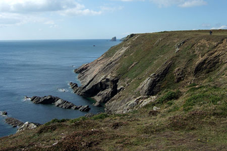
This Pembrokeshire Coast walk explores the beautiful coastline of the Marloes Peninsula. The walk follows the Pembrokeshire Coast Path for most of the way and includes the section out to Wooltack Point. Along the route there is much of interest including Marloes Beach, many rocky sections of coast and a natural arch. In addition, a short diversion to the summit of Marloes Beacon provides an excellent panorama of the route just undertaken.
The start is the National Trust car park close to Marloes Mere (grid ref. SM779082). After parking exit the car park onto the lane. Continue along the lane and take the first footpath on the right through a gate with an adjacent fingerpost. Follow the enclosed path down towards the sea. The track bears left and then sharp right to descend to the Pembrokeshire Coast Path (grid ref. SM781077). Turn west and with the sea on your left follow the well-signed path.
The path climbs offering an excellent view along the glorious sands of Marloes Beach. At the end of the beach you pass rocky Gateholm Island with Skokholm Island a few miles offshore. As you make progress, you can see ahead to Skomer Island which is a National Nature Reserve. After another section of relaxed, clifftop walking you reach a small footbridge with a gate beyond. Bear left before the gate and continue along the clear path on the cliff top.
Go through another gate in a stone wall to enter the National Trust Dee Park. Continue along the path to reach Wooltack Point from where you have an excellent view across to Skomer Island. Bear right and continue around the headland with the sea on your left passing above Wooltack Bay. Continue past the Lookout Station and descend to a gate in a substantial stone wall.
Go through the gate and turn left down the tarmac lane. At the bottom, turn right up a stepped path to reach the clifftop. You now have about three kilometres of easy walking before you leave the coast path. As you make progress you get an improving view ahead to the Nab Head. Soon Middlewick Sands come into view. Continue above the first sandy beach to reach a point where the Coast Path loops to the left around a gully. At the three-way finger post turn right away from the coast.
Follow this path reach a gate and a lane. Turn right along the lane and enjoy the view to your right. After 150 metres look out for a finger post on the left adjacent to a metal gate. You can make a short detour to the trig point on Marloes Beacon and enjoy the view across the peninsula. Return to the road, turn left, and continue for a kilometre. Turn left down a wide track just before the white house. The start of the walk is short way down this track.
Other walks nearby
| Walk 3496 | St Anne's Head & Dale Peninsula | easy/mod | 7.0 miles |
| Walk 3497 | Angle Peninsula | easy | 3.7 miles |
| Walk 2485 | Broad Haven & Druidston Circular | easy/mod | 4.9 miles |
| Walk 3498 | Freshwater West & Angle | moderate | 8.7 miles |
| Walk 1210 | Porth Clais & St Justinian's | easy/mod | 5.5 miles |
| Walk 2056 | Pointz Castle from Solva | easy/mod | 5.5 miles |
| Walk 1997 | St. David's & Coast Path Circular | moderate | 9.7 miles |
| Walk 2057 | St. David's Head & Carn Llidi | easy/mod | 4.5 miles |
| Walk 3483 | Penberry & St Davids Head from Whitesands Bay | moderate | 9.0 miles |
| Walk 3476 | Porthgain & Blue Lagoon from Abereiddy | easy/mod | 6.5 miles |
Recommended Books & eBooks
The Wales Coast Path
 A single guidebook to walking the whole Wales Coast Path - 1400km (870 miles) the length of Wales from Chester to Chepstow, including Anglesey, described in 57 stages. The route passes through the Snowdonia and Pembrokeshire National Parks and many AONBs and can be linked with the Offa's Dyke Path for a complete circuit of Wales.
More information
Messaging & Social Media
Message Walking Britain and follow the latest news.

Mountain Weather
Stay safe on the mountains with detailed weather forecasts - for iOS devices or for Android devices.