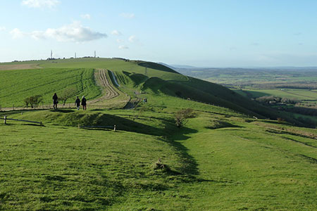
Edburton Hill & Devil's Dyke from Saddlescombe
South Downs Walk
Nat Park - South Downs
County/Area - West Sussex
Author - Lou Johnson
Length - 10.5 miles / 17.1 km Ascent - 1400 feet / 424 metres
Time - 6 hours 40 minutes Grade - hard
Walk Route Description
Click image to see photo description.
This energetic walk on the South Downs starts from Saddlescombe and follows the South Downs Way across Fulking Hill and Edburton Hill to Beeding Hill. The route then follows the Monarch's Way for a short section before returning along the escarpment via the dry valley of Devil's Dyke back to the start. The walk offers excellent views throughout along easy to follow paths.
The start is the car park opposite Saddlescombe Farm just east of the Devil's Dyke (grid ref. TQ271114). After parking turn left down the road and turn left through the gate. Do not follow the public footpath instead take the permissive path with a dark pink arrow. Descend some steps, cross a stile, and bear left and then right. Continue along the path across a field and cross a stile into access land. Ignore arrow pointing down to the right and continue up a grassy path with the steep sided dry valley of Devil's Dyke on your right. You soon join a bridleway coming in from the right. Ignore the first left fork and continue ahead to join the South Downs Way to reach a road.
The route now follows the South Downs Way for just over six kilometres. The undulating path is well-signed and offers excellent vies to the sea and north to the Weald. The first objective is Fulking Hill after which a short descent and ascent leas you over Perching Hill. After crossing the flank of Edburton Hill you descend to a col with an excellent view north. The onward path takes you across the southern flank of Truleigh Hill with its radio masts. The path then descends past the Youth Hostel to follow an access road down to Beeding Hill car park (grid ref. TQ208097).
Turn sharp left here onto the Monarch's Way. After two kilometres of easy walking along the bridleway you reach a T-junction (grid ref. TQ227091). Turn left and follow the clear path north to reach the South Downs Way on Truleigh Hill. Turn right and retrace your steps along the South Downs Way. Just after cresting Fulking Hill (grid ref. TQ263108), bear left off the South Downs Way and take the path heading to the pub and viewpoint above the Devil's Dyke.
After taking in the view return past the pub (on your right) and follow the path on the left-hand verge of Devil's Dyke Road. Ignore the first footpath on the left and continue along the road to reach the South Downs Way. Turn left through the wooden gate and continue along the clear path with the Devil's Dyke on your left. Ignore all paths on the left and continue ahead. After one kilometre of easy walking, with excellent views to your left, the path forks (grid ref. TQ268111). At this point the South Downs Way forks left and you should continue straight ahead. Continue along this path soon passing a popular viewpoint. The path curves to the left, re-joins the South Downs Way and descends to the car park used at the start of the walk.
Maps 

| Ordnance Survey Explorer OL11 | Sheet Map | 1:25k | BUY |
| Anquet OS Explorer OL11 | Digital Map | 1:25k | BUY |
| Ordnance Survey Digital Map Subscription | |||
| Latest Ordnance Survey Discounts | |||
Other walks nearby
| Walk 3488 | Devil's Dyke Circular | easy | 2.5 miles |
| Walk 3213 | Pyecombe, Devil's Dyke & Upper Beeding | easy/mod | 8.0 miles |
| Walk 1983 | Edburton Hill from Fulking | easy/mod | 6.1 miles |
| Walk 2236 | Wolstonbury Hill and Pyecombe from Patcham | moderate | 11.0 miles |
| Walk 2903 | Stanmer to Streat | moderate | 12.5 miles |
| Walk 2109 | Upper Beeding to Washington by the South Downs Way | easy/mod | 7.0 miles |
| Walk 2684 | Falmer to Pyecombe & Blackcap by South Downs Way | moderate | 8.8 miles |
| Walk 1782 | Steyning Round Hill and No Man's Land | moderate | 7.5 miles |
| Walk 1858 | Cissbury Ring and Chanctonbury Ring | moderate | 10.5 miles |
| Walk 2486 | Plumpton Green & South Downs | easy/mod | 7.7 miles |
Recommended Books & eBooks
Walks in the South Downs National Park
 Guidebook with 40 circular walks throughout the South Downs National Park, exploring the beautiful chalk hills between Eastbourne and Winchester. The walks range from under 5 miles to 11 miles, including Beachy Head and the Seven Sisters, Ditchling Beacon and hundreds of prehistoric sites. Accessible all year, but wild flowers best in spring.
More information
The South Downs Way
 Guidebook to walking the South Downs Way National Trail, a 100 mile (160km) route between Winchester and Eastbourne through the South Downs National Park, described in both directions over 12 stages. Easy walking on ancient and historical tracks, taking in wooded areas, delightful river valleys and pretty villages. With 1:25K OS map booklet.
More information
