Walk 3490 - printer friendly version
Cemaes Head & Clawddcam from Poppit Sands Walk
Author - Lou Johnson
Length - 8.3 miles / 13.5 km
Ascent - 1250 feet / 379 metres
Grade - moderate
Start - OS grid reference SN152485
Lat 52.1038800 + Long -4.6997235
Postcode SA43 3LR (approx. location only)
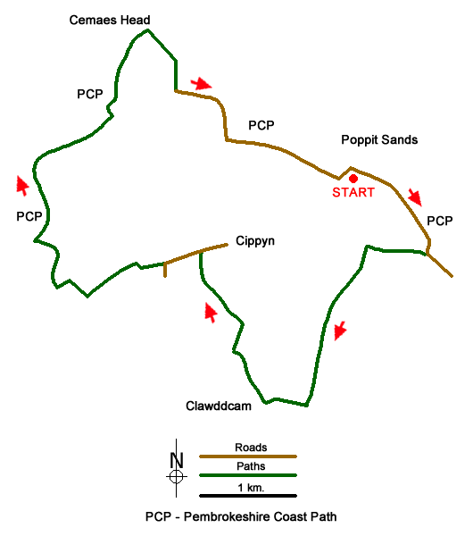
This walk to Cemaes Head in Pembrokeshire starts from Poppit Sands. The route heads south to explore the undulating countryside and uses tracks and footpaths to reach the coast at Pwyllgranant. The walk then follows the lofty Pembrokeshire Coast Path which rises to over 500 feet above the sea before reaching Cemaes Head. The route then turns east to descend to the start.
The start is the large pay and display car park behind the beach at Poppit Sands (grid ref. SN152485). Exit the car park and cross the road and turn right onto the Pembrokeshire Coast Path which runs parallel to the road at the back of the beach. Continue along the path with the sea on your left. After 600 metres the Coast Path joins the road (B4546) with the Teifi estuary on your left. Continue past the Wedley Hotel on your right. The road soon bends to the left. At this point turn right on a tarmac lane signed as a bridleway to Manian-fawr. Pass the extensive buildings at this farm and take the next track on your left (grid ref. SN153478).
Follow the clear rising track south for 1.5 kilometres to reach a cross-track (grid ref. SN147463). Turn right and continue on another clear track. Pass to the left of the farm at Clawddcam and just past the farm take the right-hand track at a fork. Pass the buildings at Tirion-isaf on your right and descend to cross a stream. Once across the stream bear half right to follow a hedge on your left. Reaching a clear track, turn right and almost immediately turn left onto a bridleway, which heads north following the field boundary which should be on your right. Pass through buildings of Esgyr-Draw farm to reach a lane (grid ref. SN138478).
Turn left along the lane. Where the lane bends to the left, continue straight ahead onto a signed grassy bridleway. The track bends right and then left to reach the large farm at Granant-isaf (grid ref. SN127474). Pass a large building on your right. At the end of this building turn right along a clear track. Follow the track to reach a house (Graig). Turn left and pass in front of the house and follow the path (with hedge on your left) down to a stream. Follow the path with the stream on your left through trees. Exiting the trees take the next path on the left and continue to reach the Pembrokeshire Coast Path at a three-way fingerpost (grid ref. SN123478).
Turn right along the coast path and head north with the sea to your left. The path climbs steadily, levels off and then climbs again with an excellent view ahead of the steep rocky cliffs. At the top of this climb you reach the highest point of the coast path on this section with a fine retrospective view south along the coast. The path undulates to reach Cemaes Head where it turns east. Another lofty section of path takes you above the cliffs. As you make progress a view towards the Teifi estuary opens ahead. A descent takes you to Allt-y-coed farm where you continue along their access drive to join a lane.
One final climb out of the valley and you have about two kilometres of downhill walking back to the start enjoying a good view across Poppit Sands and the Teifi Estuary. Reaching the Lifeboat Station bear right, and the car park is on your right with refreshments available in season at the adjacent café.
Messaging & Social Media
Message Walking Britain and follow the latest news.

Mountain Weather
Stay safe on the mountains with detailed weather forecasts - for iOS devices or for Android devices.