Walk 3497 - printer friendly version
Angle Peninsula Walk
Author - Lou Johnson
Length - 3.7 miles / 6 km
Ascent - 300 feet / 91 metres
Grade - easy
Start - OS grid reference SM854032
Lat 51.6864390 + Long -5.1059929
Postcode SA71 5BE (approx. location only)
This easy and rewarding coastal walk explores the Angle Peninsula. The route follows the Pembrokeshire Coast Path which offers some excellent views to Thorn Island, the mouth of Milford Haven and Angle Bay.
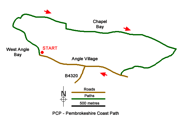
The route starts form the car park at West Angle Bay beach (grid ref. SM854032). After parking turn right along the Pembrokeshire Coast Path with the sea on your left. At the far end of the car park to join a track. Continue on the rising track, ignoring a path off to the left by two concrete blocks. At the next fork, bear left to reach a fingerpost. Take the right fork here and continue onto the top of the cliffs. You soon get views across Milford Sound.
As you make progress Thorn Island comes into view. Bear right by the concrete seat and continue along the coast path. Rounding the headland, you can see the oil and gas jetties across Milford Haven. The path follows the boundary of Chapel Bay Fort and Museum to join a tarmac road (grid ref. SM859036). Continue ahead onto a gravel track. Continue past a cottage and shortly after leave the track bearing left onto the signed coast path. Continue through a gate and follow the path between trees to pass through two more gates. The view across Milford Haven opens again on your left.
Continue along the clear path passing through a number of gates to meet a track which leads down to the lifeboat station. Go straight across the track following the fingerpost. After passing through scrub the path emerges into a field. Continue past the Old Point House (refreshments in season) and follow a gravel track at the top od the pebble beach. Passing a large house on the right and continue past some cottages on the right. Reaching a four-way fingerpost continue straight ahead. Follow the track passing the church on your right to reach a road. Turn right and follow this road (B4320) through Angle village. Continue straight ahead to reach the car park used at the start of the walk.
Messaging & Social Media
Message Walking Britain and follow the latest news.

Mountain Weather
Stay safe on the mountains with detailed weather forecasts - for iOS devices or for Android devices.