Walk 3523 - printer friendly version
Abbotsbury & Portesham Circular Walk
Author - Lou Johnson
Length - 5.2 miles / 8.5 km
Ascent - 500 feet / 152 metres
Grade - easy
Start - OS grid reference SY602857
Lat 50.6695970 + Long -2.5645546
Postcode DT3 4LX (approx. location only)
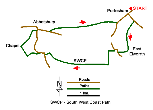
Starting from the Dorset village of Portesham this walk takes you to Abbotsbury where there is much of historic interest to explore. The route uses a section of the South West Coast Path national trail although, which in this area does not follow the coast. On street parking is available in Portesham close by the parish church (grid ref. SY602857). Do remember to park with consideration for local residents.
After parking walk south to the B3157 and follow the left hand fork towards Chickerell (Bramdon Lane). After just over 200 metres take the signed footpath on the right (grid ref. SY603855). This path leads down the side of Marsh Farm and takes you to East Elworth (grid ref. SY602846). From here turn left along the driveway to a lane (grid ref. SY599846). Turn right along the lane and follow it round to the left and into the hamlet of West Elworth. Where the lane turns right take the bridleway on the left. This soon turns right and heads west. In less than 200 metres turn left following the track between hedges and climbing slightly onto Merry Hill.
Reaching a junction of paths (grid ref. SY596843), turn right onto the South West Coast Path. This is followed for just over a mile to reach a lane at Horsepool Farm (grid ref. SY579846). Turn right along the lane and then bear left through the parking area and continue onto the southern flank of Chapel Hill. Take the path to the summit of the hill and St Catherine's Chapel. After enjoying the view over Abbotsbury descend to the north-east and continue to the centre of Abbotsbury. Allow some time to explore this beautiful village where there are a number of options for refreshments.
Having explored the village follow the B3157 east (signed Portesham). After approximately 350 metres you reach Glebe Close on your left. Immediately after this bear half left along a tarmac track. This leads to the old railway track bed. Bear right along the route of the old railway and continue for just over a mile to reach the B3157 on the outskirts of Portesham. Turn left along the B3157 and return to your car.
Messaging & Social Media
Message Walking Britain and follow the latest news.

Mountain Weather
Stay safe on the mountains with detailed weather forecasts - for iOS devices or for Android devices.