Abbotsbury & Portesham Circular
Jurassic Coast Walk
Region - Jurassic Coast
County/Area - Dorset
Author - Lou Johnson
Length - 5.2 miles / 8.5 km Ascent - 500 feet / 152 metres
Time - 3 hours 10 minutes Grade - easy
Walk Route Description
Click image to see photo description.
Starting from the Dorset village of Portesham this walk takes you to Abbotsbury where there is much of historic interest to explore. The route uses a section of the South West Coast Path national trail although, which in this area does not follow the coast. On street parking is available in Portesham close by the parish church (grid ref. SY602857). Do remember to park with consideration for local residents.
After parking walk south to the B3157 and follow the left hand fork towards Chickerell (Bramdon Lane). After just over 200 metres take the signed footpath on the right (grid ref. SY603855). This path leads down the side of Marsh Farm and takes you to East Elworth (grid ref. SY602846). From here turn left along the driveway to a lane (grid ref. SY599846). Turn right along the lane and follow it round to the left and into the hamlet of West Elworth. Where the lane turns right take the bridleway on the left. This soon turns right and heads west. In less than 200 metres turn left following the track between hedges and climbing slightly onto Merry Hill.
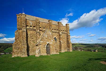
Reaching a junction of paths (grid ref. SY596843), turn right onto the South West Coast Path. This is followed for just over a mile to reach a lane at Horsepool Farm (grid ref. SY579846). Turn right along the lane and then bear left through the parking area and continue onto the southern flank of Chapel Hill. Take the path to the summit of the hill and St Catherine's Chapel. After enjoying the view over Abbotsbury descend to the north-east and continue to the centre of Abbotsbury. Allow some time to explore this beautiful village where there are a number of options for refreshments.
Having explored the village follow the B3157 east (signed Portesham). After approximately 350 metres you reach Glebe Close on your left. Immediately after this bear half left along a tarmac track. This leads to the old railway track bed. Bear right along the route of the old railway and continue for just over a mile to reach the B3157 on the outskirts of Portesham. Turn left along the B3157 and return to your car.
Maps 

| Ordnance Survey Explorer OL15 | Sheet Map | 1:25k | BUY |
| Anquet OS Explorer OL15 | Digital Map | 1:25k | BUY |
| Ordnance Survey Digital Map Subscription | |||
| Latest Ordnance Survey Discounts | |||
Other walks nearby
| Walk 2565 | Littlebredy from Abbotsbury | moderate | 8.5 miles |
| Walk 2827 | Rodden & Langton Herring from Abbotsbury | easy/mod | 9.2 miles |
| Walk 2289 | Abbotsbury Castle and Chesil Beach | easy/mod | 6.0 miles |
| Walk 2370 | The Fleet from Langton Herring | easy/mod | 7.0 miles |
| Walk 2494 | West Bexington & Abbotsbury Circular | moderate | 7.7 miles |
| Walk 1597 | The White Horse & Sutton Poyntz from Osmington | easy/mod | 4.0 miles |
| Walk 2440 | White Nothe & Moigns Down from Osmington | moderate | 10.5 miles |
| Walk 3265 | Eggardon Hill from Powerstock | easy/mod | 6.3 miles |
| Walk 3629 | Eggardon Hill from Loders | moderate | 8.4 miles |
| Walk 2391 | West Bay & Burton Cliff | easy | 4.5 miles |
Recommended Books & eBooks
South West Coast Path Map Booklet - Minehead to St Ives
 Map of the northern section of the 630 mile (1014km) South West Coast Path National Trail. Covers the trail from Minehead to St Ives along the north Devon and Cornish coastline. This convenient and compact booklet of Ordnance Survey 1:25,000 maps shows the route, providing all of the mapping you need to walk the trail in either direction.
More information
The South West Coast Path
 Guidebook to walking the entire South West Coast Path National Trail. The route runs for 630 miles from Minehead to Poole along the north Devon, Cornish, south Devon and Dorset coastline. Divided into 45 stages, this long-distance coastal trek could be completed within 4 weeks, or walked in sections. Guide includes maps and essential information.
More information
