Cat Bells (Route 2) from Gutherscale
Lake District Walk
Nat Park - Lake District - Lake District North Western Fells
Wainwrights - Catbells
County/Area - Cumbria
Author - Lou Johnson
Length - 4.0 miles / 6.5 km Ascent - 1500 feet / 455 metres
Time - 3 hours 30 minutes Grade - easy/mod
Walk Route Description
Click image to visit gallery of 12 images.
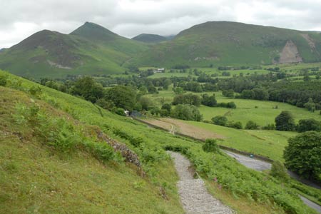
This popular Lakeland Fell rises above the western shores of Derwentwater and is the basis for an excellent short and very scenic walk. Despite its modest stature, Catbells exhibits many of the characteristics of a many larger Lakeland hills, so often provides an excellent introduction to the pleasures (and pains!) of fell walking.
The start for this Lake District walk is the small car park (Grid ref. NY246211) on the dead-end road leading to Skelgill on the northwest flank of the fell. If this area is full then additional parking can be found along the verges near the road junction. From the car park walk back down the lane and take the path rising up the hill on your right. This path gains height quickly with no navigational problems. Quite soon the views begin to appear and you forget the uphill work as you enjoy the beautiful countryside in this part of Lakeland.
Reaching the first summit of Skelgill Bank you get your first clear view of Catbells' summit. Continue ahead on the main path. In some sections you climb over rock. There are no technical difficulties although you might need your hands on a couple of short sections. Reaching the summit you have a wonderful panorama. Ahead lies Maiden Moor. To your right is a superb view into the Newlands Valley with the fells surrounding Buttermere. Moving right you have Causey Pike and other fells of the Grassmoor group. Behind Keswick is Skiddaw with Derwentwater and Borrowdale completing the view.
To continue descend south. At the lowest point of the col (Grid ref NY244192) turn sharp left and follow the path descending towards Manesty. The descent offers fine views across Derwentwater. Continue on this path to reach a clear junction of paths with the woodland almost adjacent (Grid ref NY248186). Turn sharp left and continue along this balcony path eventually reaching the lane near the start of the walk. Turn left along the lane and left at the first junction. This will take you back to the small car park where you started.
Maps 

| Ordnance Survey Explorer OL4 | Sheet Map | 1:25k | BUY |
| Anquet OS Explorer OL4 | Digital Map | 1:25k | BUY |
| Ordnance Survey Digital Map Subscription | |||
| Latest Ordnance Survey Discounts | |||
Other walks nearby
| Walk 1155 | Causey Pike | moderate | 6.3 miles |
| Walk 1187 | Robinson & Hindscarth | mod/hard | 6.5 miles |
| Walk 1356 | Walla Crag | easy/mod | 4.5 miles |
| Walk 3029 | Derwentwater & Walla Crag | easy/mod | 6.5 miles |
| Walk 3037 | High Seat & Bleaberry Fell from Keswick | moderate | 9.0 miles |
| Walk 2321 | Shores of Derwentwater | easy | 3.5 miles |
| Walk 1108 | Ashness Bridge & Grange Fell | moderate | 9.0 miles |
| Walk 1120 | Grisedale Pike & Crag Hill fro Braithwaite | mod/hard | 8.5 miles |
| Walk 2038 | Tower Ridge on Eel Crag returning via Sail & Barrow | hard | 6.3 miles |
| Walk 1268 | Cat Bells & High Spy | moderate | 8.0 miles |
Recommended Books & eBooks
Walking the Lake District Fells - Mardale and the Far East
 Part of the Walking the Lake District Fells series, this guidebook covers a wide range of routes to 36 Lakeland summits that can be climbed from the Ullswater, Haweswater, Troutbeck, Kentmere and Longsleddale valleys, with highlights including High Street, Place Fell and the Kentmere fells. Suggestions for longer ridge routes are also included.
More information
Walking the Lake District Fells - Patterdale
 Part of the Walking the Lake District Fells series, this guidebook covers a wide range of routes to 35 Lakeland summits that can be climbed from Ambleside, Grasmere and Patterdale and the Thirlmere and Ullswater valleys, with highlights including Helvellyn and Fairfield. Suggestions for longer ridge routes are also included.
More information
