Walk 3525 - printer friendly version
Cat Bells (Route 2) Walk
Author - Lou Johnson
Length - 4.0 miles / 6.5 km
Ascent - 1500 feet / 455 metres
Grade - easy/mod
Start - OS grid reference NY246211
Lat 54.57946 + Long -3.1680418
Postcode CA12 5UE (approx. location only)
This popular Lakeland Fell rises above the western shores of Derwentwater and is the basis for an excellent short and very scenic walk. Despite its modest stature, Catbells exhibits many of the characteristics of a many larger Lakeland hills, so often provides an excellent introduction to the pleasures (and pains!) of fell walking.
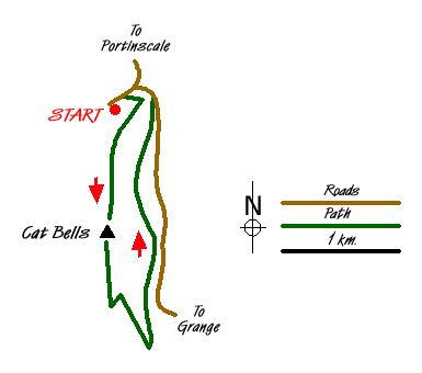
The start for this Lake District walk is the small car park (Grid ref. NY246211) on the dead-end road leading to Skelgill on the northwest flank of the fell. If this area is full then additional parking can be found along the verges near the road junction. From the car park walk back down the lane and take the path rising up the hill on your right. This path gains height quickly with no navigational problems. Quite soon the views begin to appear and you forget the uphill work as you enjoy the beautiful countryside in this part of Lakeland.
Reaching the first summit of Skelgill Bank you get your first clear view of Catbells' summit. Continue ahead on the main path. In some sections you climb over rock. There are no technical difficulties although you might need your hands on a couple of short sections. Reaching the summit you have a wonderful panorama. Ahead lies Maiden Moor. To your right is a superb view into the Newlands Valley with the fells surrounding Buttermere. Moving right you have Causey Pike and other fells of the Grassmoor group. Behind Keswick is Skiddaw with Derwentwater and Borrowdale completing the view.
To continue descend south. At the lowest point of the col (Grid ref NY244192) turn sharp left and follow the path descending towards Manesty. The descent offers fine views across Derwentwater. Continue on this path to reach a clear junction of paths with the woodland almost adjacent (Grid ref NY248186). Turn sharp left and continue along this balcony path eventually reaching the lane near the start of the walk. Turn left along the lane and left at the first junction. This will take you back to the small car park where you started.
Messaging & Social Media
Message Walking Britain and follow the latest news.

Mountain Weather
Stay safe on the mountains with detailed weather forecasts - for iOS devices or for Android devices.