Walk 3582 - printer friendly version
Castell y Bere & Llanfihangel-y-pennant from Abergynolwyn Walk
Author - Lou Johnson
Length - 5.7 miles / 9.3 km
Ascent - 800 feet / 242 metres
Grade - easy/mod
Start - OS grid reference SH677069
Lat 52.6436590 + Long -3.9567963
Postcode LL36 9YW (approx. location only)
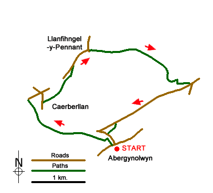
This Snowdonia (Eryri) walk starts from Abergynolwyn which lies on the B4405 northeast from Tywyn. The route offers an interesting circuit with some fine scenery. Route finding is generally good although the path leading up from Llanfihangel-y-pennant was overgrown in places. Parking is available in the village centre by the community centre (grid ref. SH677069) where refreshments are available.
After parking, turn left along the B4405 towards Tywyn. Just before the bridge turn right down a tarmac track to the left of the play area. Turn left over the footbridge and bear to the right of a house. The onward path then continues across a field to reach the Afon Dysynni, which is on your right. Stay on the clear path which follows the river and gradually descends to pass in front of a house (grid ref. SH660078). Continue to the lane. Turn right over the river and continue along the lane. Ignore the lane on the left and take the next right (signed to Abergynolwyn). Turn left onto the driveway leading to Caerberllan, impressive farmhouse, and then continue along the bridleway. This climbs gently before levelling out to offer a fine view across the valley to the left which includes Castell y Bere.
About 800 metres beyond Caerberllan, take the path on the left through a kissing gate (grid ref. SH668083). The path slants right across the field and descends to a lane. Go right along the lane passing the entrance to Castell y Bere which is worth a visit if you have time. Stay on the lane to reach the small church at Llanfihangel-y-pennant which is on your left.
Turn right opposite the entrance to the churchyard along a drive leading to a house. Continue on the waymarked path which climbs beside a stream (on your right) with several small waterfalls. The path continues to climb through trees and soon reaches open pastures. Continue ahead still with the stream on your right and join a track (grid ref. SH679089). Continue ahead on the track which climbs gently soon reaching an old ruined building, Nant-yr-eira. Continue ahead through the gate and with the stream on your right. Bear right alongside a broken wall (wall on your left) to reach a gate.
Continue ahead down the track. The track turns sharp left and after just over 100 metres turn right down a path through woodland to reach a lane (grid ref. SH692081). Turn right along the lane and follow it towards Abergynolwyn. Just path a bungalow below you on the left, turn left down some steps to follow a signed footpath that drops down to the river and leads to a lane. Turn left along the lane back to the start.
Messaging & Social Media
Message Walking Britain and follow the latest news.

Mountain Weather
Stay safe on the mountains with detailed weather forecasts - for iOS devices or for Android devices.