Walk 3600 - printer friendly version
Totteridge and Whetstone circular (London Borough of Barnet) Walk
Author - Peter Smyly
Length - 8.7 miles / 14.1 km
Ascent - 500 feet / 152 metres
Grade - easy/mod
Start - OS grid reference TQ261939
Lat 51.6297910 + Long -0.17953145
Postcode N20 9QJ (approx. location only)
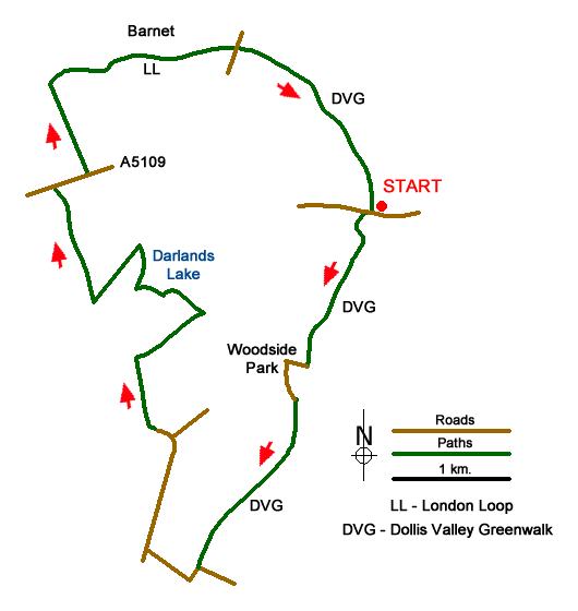
The start and end point for this route, Totteridge and Whetstone tube station, is on the London Underground, one stop before the end of the High Barnet branch of the northern line. Alternatively, three other nearby stations, Woodside Park, West Finchley and Mill Hill East can also be used to join the route. The walk includes a visit to the Darlands Lake Nature Reserve where there is a pond surrounded by woodland.
The Dollis Valley Greenwalk can be accessed just a short distance from exiting Totteridge and Whetstone station and a section of this walk also includes part of the London Loop between Barnet to the north and Totteridge to the south. The Dollis Valley Greenwalk has been designed as a link between the Capital Ring and the London Loop and it follows a similar theme of following green spaces through suburbia as far as possible. Indeed, there may be times when you wonder if some of this pretty rural scenery could be part of London at all. That said, there are reminders of the proximity of the city as the route unavoidably involves walking by and across roads at certain points in order to join up the public footpaths and the section of the London Loop is in proximity to the houses of the southern periphery of Barnet.
Although the walk is mostly on the level, depending on recent weather conditions, some sections of it may involve walking over ground which is wet and muddy - therefore come prepared with suitable footwear.
Exit Totteridge and Whetstone tube station and cross with care the busy road outside the station, Totteridge Lane, then bear right down the hill to locate and follow the signed Dollis Valley Greenwalk to the left along a tarmac path with the Dollis Brook on your right.
Follow the route ahead with occasional trains on the northern line passing by on your left. When the route reaches a road called Tillingham Way, leave the Dollis Brook temporarily at this point. Turn right here and then left along a road called Southover. The route leaves this road on the left between metal gates to continue along a path with the Dollis Brook reappearing on the left.
Follow the route ahead as the route passes an allotment at Fursby Avenue then, when a huge viaduct appears ahead, passing underneath it to take the next road on the right, Abercorn Road, at the end of which turn right along Frith Lane. Next follows a section of road walking alongside this busy road but there is a pavement all the way and just before the road bends round to the right, take the next road on the left, Partingdale Lane. When this road bends round to the right, a view opens out ahead of fields and farmland and a sign for a public bridleway appears on the right. Leave the road at this juncture and follow the bridleway, Burtonhole Lane.
Note - although the Explorer Map for London North 173 shows a public footpath a little further on from the turning along Partingdale Lane, I do not recommend this route as it involves crossing fields which may be wet and muddy, and the route ahead is not immediately obvious.
At the end of Burtonhole Lane, at a T junction of paths, turn right. Take the next path on the left and follow it gently uphill initially then downhill. When you come to a T junction of paths, bear left as the track leads to a stream on the right, the Folly Brook. The track now keeps company with the stream for the next few hundred yards, crossing it three times, at a wooden footbridge, then a wooden plank and finally a fallen tree. Shortly after this, an embankment appears ahead, beyond which, Darland's Lake comes into view, more of a large pond than a lake. Turn left here to cross the outflow at a bridge and follow the path ahead as it contours round to the right. When a path appears on the right, ignore this, unless you want to go back to the lake, and instead take the path ahead, due north leading to a T junction of paths.
Note: An option to curtail the walk at this juncture is to bear right which will take you back to Totteridge and Whetstone by a much more direct route.
For this route, take the left turning. There is a very rural feel about this section with sweeping views across fields. Emerging from woodland, cross the next field which can be muddy in parts and at the next path junction turn sharp right. This track gradually rises between fields where grazing sheep may be seen and, looking back, the urban sprawl of London appears with some familiar distant landmarks such as the Shard, reminding you that despite the rural feel, London is not far away. The track emerges at the busy A5109.
Cross the road with care and bear right along the pavement. Take the next signed public footpath on the left at Horseshoe Lane, a road initially, leading to a wooden stile and down across fields. Where a muddy path bends round to the left, ignore this but walk through a gap in the hedge to cross a field to locate a metal footbridge across the Dollis Brook. The houses of High Barnet have come into view by now across a grassy field and this will continue to be the theme for the next mile or so as you follow parts of both the London Loop and the Dollis Valley Greenway where they coincide through an area called Ducks Island.
The route follows between the stream on the right and houses on the left, continuing along a tarmac path to cross a road with signs for the London Loop. Keep ahead with a stream on your right and open playing fields to the left. Turn right at the next path junction. Follow the Dollis Valley Greenway for the next mile or so to return to the start point of the walk.
Messaging & Social Media
Message Walking Britain and follow the latest news.

Mountain Weather
Stay safe on the mountains with detailed weather forecasts - for iOS devices or for Android devices.