Walk 3626 - printer friendly version
The Fovant Badges from Broad Chalke Walk
Author - Chris Heaton
Length - 9.3 miles / 15.1 km
Ascent - 600 feet / 182 metres
Grade - easy/mod
Start - OS grid reference SU040254
Lat 51.0279540 + Long -1.9443378
Postcode SP5 5EJ (approx. location only)
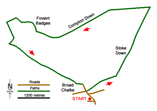
This pleasant Wiltshire walk starts from the village of Broad Chalke with the main objective a visit to the Fovant Badges, which were replicas of regimental cap badges that were constructed during the First World War by regiments on their way to the front. Along the way, the route crosses some fine rolling countryside and passes the Iron-age fort at Chislebury.
The start is the free car park on the Causeway behind All Saints Parish Church (grid ref. SU040254). After parking exit the car park and turn left, cross the river and continue to a T-junction with the Queen's Head opposite. Turn left and follow the road around to the right. Just past a thatched cottage, turn right into Tank Lane. Where the tarmac ends, bear left passing a house on your right following the signed bridleway. The path continues through trees to enter a large field. Continue across the field with the hedge to your left. Continue across a second field again with the hedge on your left to reach a track (grid ref. SU049262).
Turn left along the track. Continue straight ahead between the buildings at Stoke Farm. The clear track continues over Stoke Down. You soon pass through some trees after which you reach the point where the main track turns left. Continue ahead soon passing an area of woodland on your right. Where the tracks veers left take the signed path on the right (grid ref. SU058280). Continue across a field following three solitary trees. The route enters a wood where you keep ahead ignoring cross tracks. Reaching a gated junction (grid ref. SU062288), turn left onto the Old Shaftesbury Drove.
Keep straight ahead for about 5 kilometres. Along this section you cross Compton Down and can enjoy some fine views especially to Knapp Down on your left. You reach a gate on your right (grid ref. SU191279) which provides access to Chislebury Camp. The path goes to the right of the Iron-age fort, which can be explored if you have time. The waymarked path then descends half left across the steep hillside passing through the protected Fovant Badges. Reaching the bottom of the escarpment, go right through a gate and continue to the road at East Farm (grid ref. SU011284).
Turn left along the lane. Reaching the point where the lane bends to the left, take the signed footpath on the left by a metal farm gate. The path crosses a field with the fence and later a hedge on your left. After a gate the bridleway goes half right up Fovant Down. Nearing the top head left along a track which has joined from the right (grid ref. SU004274). After 250 metres you reach a gate and a cross track (Old Shaftesbury Drove). Go straight across with the field boundary to your right. The clear track the passes through trees to reach an open area where the track swings to the right (grid ref. SU020266). Continue straight ahead with the fence on your left. After 600 metres you pass a bridleway on your right. Ignore this and continue straight ahead. Continue through farm buildings to a lane. Turn right and follow the lane down into Broad Chalke. You soon re-join the outward route to return to the start.
Messaging & Social Media
Message Walking Britain and follow the latest news.

Mountain Weather
Stay safe on the mountains with detailed weather forecasts - for iOS devices or for Android devices.