Walk 3634 - printer friendly version
Catterick Moss & Bollihope Carrs Walk
Author - Lou Johnson
Length - 5.6 miles / 9.1 km
Ascent - 900 feet / 273 metres
Grade - moderate
Start - OS grid reference NY983363
Lat 54.7216930 + Long -2.0279130
Postcode DL13 2PN (approx. location only)
This North Pennine walk in County Durham explores two summits, Catterick Moss and Bollihope Carrs, which are located near Stanhope on the south side of Weardale. The route is not for inexperienced walkers as the walk needs good navigation skills, a 1:25k map and a good sense of direction. In addition, paths are intermittent with rough ground in places and often wet. If there is low cloud, then I recommend you save the walk for another day.
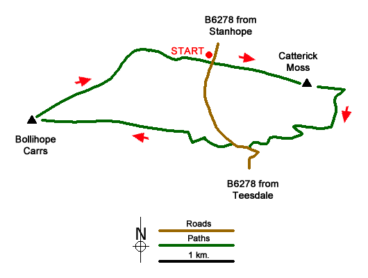
To reach the start take the Barnard Castle road (B6278) out of Stanhope. Just after crossing the highest point there is a small area for off road parking (grid ref. NY983363). From here you should be able to see the cairn on Catterick Moss to the east and a similar structure on Bollihope Carrs to the west. It is also worth making a mental note of the general lie of the land.
The first objective is the cairn on Catterick Moss. Leaving the road choose the easiest route across the rough moor aiming for the cairn which is in sight for all this section. As you get nearer keep to the right of a rocky outcrop. Continue to the OS trig column. Maintaining direction continue for a further 200 metres from where you have an extensive view east into Weardale. From this viewpoint, trend slight right and descend to a track (grid ref. NY999358). Go right where the tracks forks and continue along the track into valley heading for a small plantation (grid ref, NY990352). Continue to the road.
Turn right up the road to a small parking area on the left 50 metres beyond the bridge. Take the left-hand of the three tracks and bear right up to walled enclosure. Bear left along the wall and follow it round to the right to end of the enclosure. From this point you have a clear view to Bollihope Moss. There is no path so head west choosing your route with care. Clamber up through rocks to the trig column and enjoy the view west across Upper Weardale.
Continue to the cairn from where you can see your starting point. From the cairn a grassy track heads northeast. In places the track becomes indistinct. Continue to cross a stream, take the second fork right (grid ref. NY973363) and continue east back to the start.
Messaging & Social Media
Message Walking Britain and follow the latest news.

Mountain Weather
Stay safe on the mountains with detailed weather forecasts - for iOS devices or for Android devices.