Catterick Moss & Bollihope Carrs
North Pennines Walk
Region - North Pennines
County/Area - Durham
Author - Lou Johnson
Length - 5.6 miles / 9.1 km Ascent - 900 feet / 273 metres
Time - 3 hours 40 minutes Grade - moderate
Walk Route Description
Click image to see photo description.
This North Pennine walk in County Durham explores two summits, Catterick Moss and Bollihope Carrs, which are located near Stanhope on the south side of Weardale. The route is not for inexperienced walkers as the walk needs good navigation skills, a 1:25k map and a good sense of direction. In addition, paths are intermittent with rough ground in places and often wet. If there is low cloud, then I recommend you save the walk for another day.
To reach the start take the Barnard Castle road (B6278) out of Stanhope. Just after crossing the highest point there is a small area for off road parking (grid ref. NY983363). From here you should be able to see the cairn on Catterick Moss to the east and a similar structure on Bollihope Carrs to the west. It is also worth making a mental note of the general lie of the land.
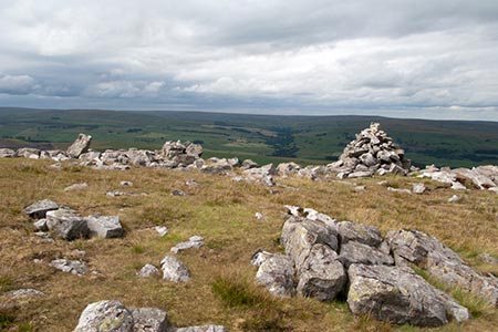
The first objective is the cairn on Catterick Moss. Leaving the road choose the easiest route across the rough moor aiming for the cairn which is in sight for all this section. As you get nearer keep to the right of a rocky outcrop. Continue to the OS trig column. Maintaining direction continue for a further 200 metres from where you have an extensive view east into Weardale. From this viewpoint, trend slight right and descend to a track (grid ref. NY999358). Go right where the tracks forks and continue along the track into valley heading for a small plantation (grid ref, NY990352). Continue to the road.
Turn right up the road to a small parking area on the left 50 metres beyond the bridge. Take the left-hand of the three tracks and bear right up to walled enclosure. Bear left along the wall and follow it round to the right to end of the enclosure. From this point you have a clear view to Bollihope Moss. There is no path so head west choosing your route with care. Clamber up through rocks to the trig column and enjoy the view west across Upper Weardale.
Continue to the cairn from where you can see your starting point. From the cairn a grassy track heads northeast. In places the track becomes indistinct. Continue to cross a stream, take the second fork right (grid ref. NY973363) and continue east back to the start.
Maps 

| Ordnance Survey Explorer OL31 | Sheet Map | 1:25k | BUY |
| Anquet OS Explorer OL31 | Digital Map | 1:25k | BUY |
| Ordnance Survey Digital Map Subscription | |||
| Latest Ordnance Survey Discounts | |||
Other walks nearby
| Walk 2393 | Weardale Circular from Westgate | easy/mod | 6.4 miles |
| Walk 1948 | Tunstall Reservoir | easy/mod | 7.3 miles |
| Walk 1955 | Sunnyside Edge from Wolsingham | easy/mod | 7.5 miles |
| Walk 3099 | High Force, Low Force and the River Tees | easy/mod | 7.5 miles |
| Walk 2382 | Smiddy Shaw Reservoir Circular | easy/mod | 6.2 miles |
| Walk 1005 | Harter Fell & Grassholme | moderate | 8.0 miles |
| Walk 1482 | Crossthwaite Common from Middleton-in-Teesdale | moderate | 9.8 miles |
| Walk 1483 | Eggleston & Romaldkirk from Middleton-in-Teesdale | easy/mod | 9.8 miles |
| Walk 1484 | Kirkcarrion from Middleton-in-Teesdale | easy | 3.5 miles |
| Walk 1485 | Hamsterley & Middleton-in-Teesdale | mod/hard | 16.5 miles |
Recommended Books & eBooks
Great Mountain Days in the Pennines
 An inspirational guidebook to 50 classic walks on the rolling Pennine landscape. The graded routes, between 6 and 13 miles in length, cover classic Pennine fells and moorland such as Whernside, Ilkley Moor and Pendle Hill; exploring the North and South Pennines, Yorkshire Dales, Howgills and Dark Peak. Many routes are also suited to fell running.
More information
Walking in County Durham
 Guidebook offering detailed descriptions of 40 day walks, plus 10 traffic-free cycle routes along old railway trackbeds. Together they cover 450 miles and spread all over County Durham to show the region's history and natural wonders. The terrain covered ranges from field paths to open moorlands, from the North Sea to the high Pennines.
More information
