Walk 3636 - printer friendly version
Bibury & Ablington Circular Walk
Author - Lou Johnson
Length - 4.1 miles / 6.7 km
Ascent - 250 feet / 76 metres
Grade - easy
Start - OS grid reference SP115067
Lat 51.7588710 + Long -1.8347851
Postcode GL7 5NN (approx. location only)
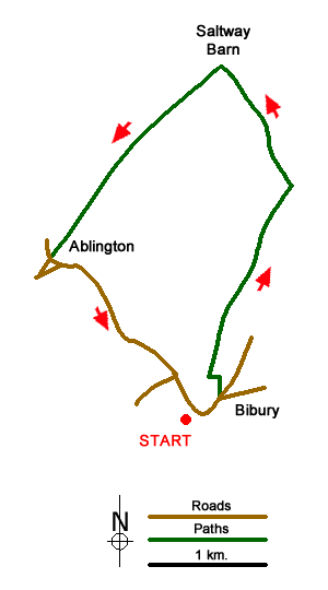
This short Gloucestershire circular walk in the Cotswolds explores the countryside to the north of the attractive village of Bibury. The routes uses well defined tracks and country lanes. The return leg of the route passes through Ablington village with its delightful cottages in a rural setting.
Parking in Bibury is available in a lay-by beside the River Coln just north of the small footbridge across the river (grid ref. SP115067). With the river on your right, walk south along the B4425, past the Post Office and around a left-hand bend. Continue to the end of the pavement, pass a letter box in the wall on your left and take the next left (Packhorse Lane) signed as a no-through road. The track bends left and then shortly after heads right and continues as a grassy track. Stay on the bridleway for about a kilometre, passing the rear of Bibury Far on your right and a barn on the left to reach a junction of tracks (grid ref. SP123082).
Take the left-hand-fork through a gate and follow the bridleway for a kilometre to reach Saltway Barn at a junction of tracks (grid ref. SP118092). Turn left along a bridleway, which is enclosed by hedges for part of the way, for two kilometres to reach a lane in Ablington village. Turn left along the lane and continue back to Bibury.
Messaging & Social Media
Message Walking Britain and follow the latest news.

Mountain Weather
Stay safe on the mountains with detailed weather forecasts - for iOS devices or for Android devices.