Walk 3694 - printer friendly version
River Thurne & Hickling Broad from Potter Heigham Walk
Author - Lou Johnson
Length - 6.4 miles / 10.4 km
Ascent - 100 feet / 30 metres
Grade - easy/mod
Start - OS grid reference TG419185
Lat 52.7100570 + Long 1.5796447
Postcode NR29 5JE (approx. location only)
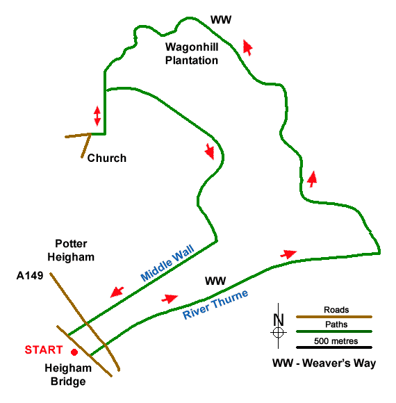
This Norfolk walk explores the watery landscape lying to the west of Potter Heigham in the Broads. The route includes a section of the Weaver's Way from Heigham Bridge that initially follows the banks of the River Thurne past High's Drainage Mill. The walk then turns north along Candle Dyke to follow the shore of Hickling Broad. Turning inland the route continues to visit St Nicholas Church before returning to the start across wet pastures. In season the walk provides the opportunity to see a variety of birds.
The start is Lathams car park at Potter Heigham Bridge (grid ref. TG419185). Please note there is a three hour limit at this car park. An alternative place to park is by the village hall. After parking walk to towards the old Potter Heigham Bridge. Just before this bridge bear left along the north bank of the River Thurne following the Weaver's Way. Continue past High's Drainage Mill. Just over one kilometre after the mill, the path turns north alongside Candle Dyke. Continue along the Weaver's Way for 4 kilometres passing Sound Plantation and Wagonhill Plantation.
Reaching a bird hide opposite Rush Hill Lagoon (grid ref. TG423209) continue for a further 300 metres to a path junction with a fingerpost (grid ref. TG421206). Turn left here and pass through Coll's Plantation. Continue ahead at the next path junction to reach a T-junction of paths (grid ref. TG421201). Turn right following the green arrow to join a road where you turn left to reach St Nicholas Church.
After visiting the church retrace your steps back to the edge of Coll's Plantation (grid ref. TG421204) where your turn right along the southern boundary of the wood (trees on your left). The path passes beside the southern edge of Wagonhill Plantation to pass Glebe Farm (grid ref. TG428197). Continue ahead here. 400 metres beyond the farm you reach a T-junction of paths with High's Drainage Mill in view ahead. Turn right following the yellow arrow and walk beside Middle Wall drainage channel to reach the A419. Cross this road with care and take the footpath opposite. After a further 200 metres, turn left back to the car park.
Messaging & Social Media
Message Walking Britain and follow the latest news.

Mountain Weather
Stay safe on the mountains with detailed weather forecasts - for iOS devices or for Android devices.