Walk 3718 - printer friendly version
Scarth Wood Moor from Osmotherley Walk
Author - Lou Johnson
Length - 6.0 miles / 9.8 km
Ascent - 750 feet / 227 metres
Grade - easy/mod
Start - OS grid reference SE456972
Lat 54.3682810 + Long -1.2996539
Postcode DL6 3BJ (approx. location only)
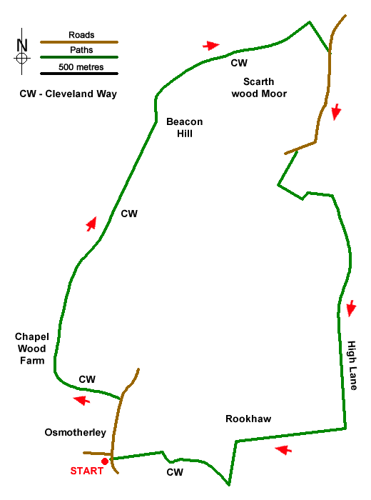
This circular walk in the North York Moors National Park starts from the attractive village of Osmotherley. The route heads north along the Cleveland Way offering some fine views west to the Vale of York before reaching Beacon Hill. The walk continues onto Scarth Wood Moor from where the route heads south beside Pamperdale Moor to regain the Cleveland Way to return to the start.
The start is the centre of the village where North End, South End and West End intersect (grid ref. SE456972). After parking follow North End which rises gentle flanked by cottages. After 400 metres at the top of the village turn right on the Cleveland Way by the fingerpost (grid ref. SE457976). Follow Ruebury Lane enjoying improving views west across the Vale of York. You soon reach Chapel Wood Farm with an old railway wagon acting as a store (grid ref. SE452980). Keep the wagon on your left, pass through the gate and continue along the Cleveland Way with good views to your left continuing to distract.
You soon reach a gate that provides access to South Wood (grid ref SE454986). Go through the gate and take the right fork signed the Cleveland Way. A steady climb up through the trees leads to a more open landscape with views return on your left. The path arrives at a wall which you keep to your right. Pass the telecoms station on your left and you soon arrive at the summit of Beacon Hill (grid ref. SE460977).
Pass through a gate (grid ref. SE460999) and continue along the Cleveland Way across Scarth Wood Moor. Reaching a three-way fingerpost (grid ref. SE471003) turn right up the Bridleway and continue to a road (grid ref. SE472001). Turn right along the road and continue for 1.5 km to the first car park on the left. Ignore this car park and continue to a smaller parking area on the left where turn left through a kissing gate and over a footbridge into the trees. After 40 metres go left up the bank of the stream. Reaching the edge of the trees go left to a ladder stile (grid ref. SE470990). Follow the path along the edge of the wood to reach High Lane (grid ref. SE471991).
Follow High Lane (a track) south with the trees to your right. 400 metres past the end of the trees you reach a fingerpost on the right with a chain across the track. Turn right here and follow the grassy track. Cross over a horse gallop, and then turn left down Green Lane. Continue south for 300 metres to join the Cleveland Way (grid ref. SE465970). Turn right and follow the waymarked Cleveland Way back to the centre of Osmotherley.
Messaging & Social Media
Message Walking Britain and follow the latest news.

Mountain Weather
Stay safe on the mountains with detailed weather forecasts - for iOS devices or for Android devices.