Walk 3745 - printer friendly version
Ventnor Downs Circular Walk
Author - Lou Johnson
Length - 7.7 miles / 12.5 km
Ascent - 1200 feet / 364 metres
Grade - moderate
Start - OS grid reference SZ573787
Lat 50.6052140 + Long -1.1916381
Postcode PO38 1PS (approx. location only)
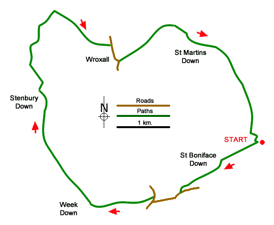
This circular walk from near Ventnor (Isle of Wight) offers an energetic route exploring the downs lying to the north of the town. The walk follows a clockwise route across the downs to reach Appuldurcombe Park. From here the route continues through the village of Wroxall to continue across the downs back to the start. The walk follows tracks and paths which are generally easy to follow although the use of a relevant map may be help navigation. Throughout the walk you can enjoy extensive views of coast and countryside of the Isle of Wight.
The start is the car park on Bonchurch Down (grid ref. SZ573787) which is reached by following Down Lane from the B3327 Newport Road on the northern outskirts of Ventnor. The drive over Wroxall Down to reach the start also offers some excellent views.
After parking, turn to face the entrance to the car park. Take the grassy path to the left of the access track soon reaching a junction several paths. Turn left and follow a clear path that soon runs beside the fence to the radar station (fence on your right). Follow this path across the down to reach a large radio mast (grid ref. SZ568783). Continue ahead through a gate and follow the track as it descends steeply down the western flank of St. Boniface Down.
Reaching the bottom, pass through gate and continue down steps to reach Old Station Road. Turn left and then right onto the B3327 (Ocean View Road). Follow the B3327 for just over 700 metres to the point where the road bends sharp right where you turn left into Steephill Down Road (brown sign to the golf course). After 600 metres from the B3327 the track forks (grid ref. SZ551776). Take the left fork and take the grassy path to turn right onto the Stenbury Trail (grid ref. SZ546775) signed to 'Stenbury Down'.
Stay on the Stenbury Trail which climbs steadily beside the golf course. You soon reach the ridge continuing to follow the bridleway (ignoring all turnings) to reach a surfaced track and a small car park (grid ref. SZ539789). Continue ahead on the surfaced track to a radio mast. Continue past the mast and then bear right along a footpath beside a fence on your left. The path veers left and becomes enclosed between fences. At the next junction cross the stile on your right and follow the path across the down to an obelisk which can be seen ahead.
Bear right downhill heading northeast down grass. A more defined path then continues north still descending to a wall and a junction (grid ref. SZ538805). Turn right along the Worsley Trail And continue to another junction reached in 350 metres (grid ref. SZ540808). On the right is Freemantle Gate, an archway built around 1770. Turn right at this junction and keep straight ahead on a bridleway (Stenbury Trail). If you wish to visit the House, then fork right and return to the route nearer Wroxall. Continue along this bridleway to reach a road (SZ547802). Keep straight ahead and continue to reach the B3327 in Wroxall.
Turn right along the B3327 for 350 metres and turn left into Castle Road with bollards across the road. Continue uphill passing the cemetery on your right. At the end of the cemetery bear right onto the Worsley Trail. Keep right at several junctions to reach a bridle gate. Go through bridle gate and head diagonally left up a grassy slop to join a well-defined path heading for the top of Shanklin Down. Continue with the fence on your left to reach the top of Shanklin Down. (A kissing gate provides access to the trig point which offers a fine view.) Continue beside the fence along the ridge to cross Luccombe Down. As you make progress the car park used at the start becomes visible on your left.
Messaging & Social Media
Message Walking Britain and follow the latest news.

Mountain Weather
Stay safe on the mountains with detailed weather forecasts - for iOS devices or for Android devices.