Nare Head & Portloe from Veryan
Cornwall AONB Walk
Region - Cornwall AONB
County/Area - Cornwall
Author -
Length - 7.0 miles / 11.4 km Ascent - 1450 feet / 439 metres
Time - 5 hours 0 minutes Grade - moderate
Maps 

| Ordnance Survey Explorer 105 | Sheet Map | 1:25k | BUY |
| Anquet OS Explorer 105 | Digital Map | 1:25k | BUY |
| Ordnance Survey Landranger 204 | Sheet Map | 1:50k | BUY |
| Anquet OS Landranger 204 | Digital Map | 1:50k | BUY |
Walk Route Description
Click image to see photo description.
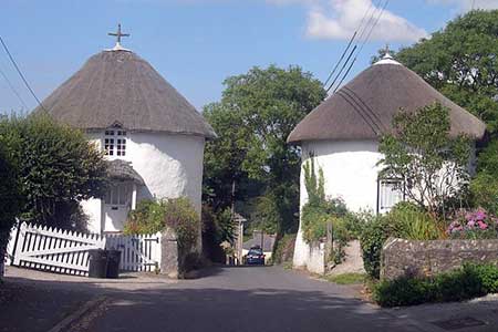
This Cornwall walk combines some fine Cornish countryside, with an interesting village and a section of the South West Coast Path. The outward leg along the coastal path has plenty of ups and downs and is not for those wanting a gentle stroll beside the sea. The views of the coastline are superb and conclude with a visit to the small harbour and village at Portloe. The return leg is across fields and along typical Cornish lanes with the opportunity to explore Veryan and its well-known round houses that guard entry to the village.
The start is in the centre of Veryan where limited parking is available near the Village Hall (Grid ref. SW 916395). Locate the New Inn and follow the St Mawes road out of the village going past the cricket ground on your left. The road narrows and descends steeply to reach Melinsey Mill. At the sharp bend turn left along the footpath to Pendower Beach. This path climbs up the side of the valley before descending again to cross a bridge. Continue through the grounds of Lower Mill following the footpath on the eastern side of the stream to reach Pendower Beach. If the tide permits turn left along the beach or else use the access road and high level path to reach Carne Beach. Leave the sands at the main access point for Carne Beach to reach the lane. Turn left along this for a short way before turning right up steps to a gate leading to the cliff path. You are now on the South West Coast Path and you stay with this for the remaining coastal section through to Portloe.
As with all coastal walking expect plenty of ascent and descent and allow longer than you might expect to complete the walk. Reaching Nare Head you have reached the highest point of the walk and you can enjoy the excellent views in both directions. Continue eastwards past Rosen Cliff to descend to Kiberick Cove. To regain the cliff top the path climbs in zigzags to reach a white house at the top. Here the path passes through a small pine plantation before descending to Portloe.
The small harbour is picturesque and the village boasts a pub, hotel and cafe making it a pleasant place to take a break. To continue head west uphill passing the Ship Inn on your right. Locating the footpath on the right to Trewartha is not easy and you need to use your map reading skills to find this one! At the time of writing it went directly in front of "Old White Cottage" past a couple of newer houses to enter a field. Trend right across this field to reach a gate. Keeping the wall on your left to reach a final gate at the top of the field. This leads onto a farm track that leads to Trewartha.
Turn left at the lane at the top and then immediately right past the Methodist church. Look out for a signed footpath on your right and take this across meadows to reach the road in Veryan Green. Turn left back to the starting point.
Note - There are six roundhouses in Veryan. Two located on the eastern edge of Veryan Green, two on the road to Portloe via Camels and two on the lane to Gwendra.
Other walks nearby
| Walk 1033 | Dodman Point & Gorran Haven | mod/hard | 11.0 miles |
| Walk 2003 | Cowlands, Coombe & Roundwood Quay from Trelissick | easy/mod | 9.0 miles |
| Walk 1783 | Gorran Haven & Dodman Point | easy/mod | 5.0 miles |
| Walk 2088 | Rosemullion Head & Mawnan | easy | 4.0 miles |
| Walk 2007 | Helford Passage & Frenchman's Creek | easy/mod | 7.0 miles |
| Walk 2009 | Gillan & Nare Point from Porthallow | easy | 4.7 miles |
| Walk 3112 | Soar Mill Cove & Bolt Head from Higher Soar | easy/mod | 6.5 miles |
| Walk 1030 | Fowey & Gribbin Head | moderate | 8.0 miles |
| Walk 1778 | Maenporth and Helford Passage Circular | easy/mod | 8.0 miles |
| Walk 2294 | St. Agnes to Porthtowan | easy/mod | 5.0 miles |
Recommended Books & eBooks
Walking in Cornwall
 This guidebook includes routes to 40 day walks in Cornwall. From short, easy strolls to longer, wilder routes, there is plenty to appeal to both families and experienced walkers. The walks explore the interior and coasts, including walks through picturesque villages, old tin-mining areas and the Lizard and Land's End Peninsulas.
More information
South West Coast Path Map Booklet - St Ives to Plymouth
 Map of part of the southern section of the 630 mile (1014km) South West Coast Path National Trail. Covers the trail from St Ives to Plymouth along the west Cornwall and Devon coastline. This convenient and compact booklet of Ordnance Survey 1:25,000 maps shows the route, providing all of the mapping you need to walk the trail in either direction.
More information
Messaging & Social Media
Message Walking Britain and follow the latest news.

Mountain Weather
Stay safe on the mountains with detailed weather forecasts - for iOS devices or for Android devices.