Gorran Haven & Dodman Point
Cornwall AONB Walk
Region - Cornwall AONB
County/Area - Cornwall
Author - Lou Johnson
Length - 5.0 miles / 8.1 km Ascent - 1000 feet / 303 metres
Time - 3 hours 30 minutes Grade - easy/mod
Walk Route Description
Click image to see photo description.
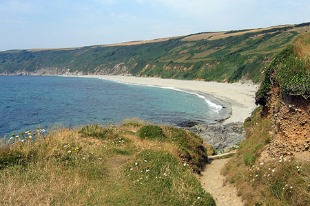
This Gorran Haven walk explores the coast south to Dodman Point from where extensive views along the coast and inland can be enjoyed. The route follows the South West Coast Path to Hemwick Bay where the walk turns inland back to Gorran Haven. The start is the main pay and display car park (grid ref. SX011416).
After parking exit the car park and turn left and continue down to the sea. Just before reaching the sea, turn right up Foxhole Lane. As the lane bends right, continue ahead up steps to follow the signed South West Coast Path. The path continues along the clifftops and continues around Maenease Point. Continue along the main coast path which is the higher of the paths above Bow Beach. If you take the narrower lower path, it re-joins the main coast path at the end of Bow beach.
The path turns south and leads to Dodman Point from where you can enjoy an extensive view from the Lizard in the west to Fowey in the east. The path then turns north with path descending towards Hemmick Beach. Just before Hemmick Beach, fork right onto a clear rising path that leads to a lane and the National Trust car park at Penare (grid ref. SW999404).
Turn right up the lane and follow the lane round to the left and through the village. Continue up hill to a T-junction (grid ref. SX000407) where you take the signed footpath through a gate. The path crosses the right-hand side of a field and then enters a campsite. Continue ahead along a track to reach the main access drive for Teveague Farm. Turn right towards the farm and then left through the farmyard to join a signed path. Which descends a steep sided valley with some trees. The path leads between houses to join Rice Lane. Turn right and follow the lane back to the start.
Maps 

| Ordnance Survey Explorer 105 | Sheet Map | 1:25k | BUY |
| Anquet OS Explorer 105 | Digital Map | 1:25k | BUY |
| Ordnance Survey Digital Map Subscription | |||
| Latest Ordnance Survey Discounts | |||
Other walks nearby
| Walk 1033 | Dodman Point & Gorran Haven | mod/hard | 11.0 miles |
| Walk 1027 | Nare Head & Portloe | moderate | 7.0 miles |
| Walk 3112 | Soar Mill Cove & Bolt Head from Higher Soar | easy/mod | 6.5 miles |
| Walk 1030 | Fowey & Gribbin Head | moderate | 8.0 miles |
| Walk 2690 | Portscatho & Porthmellin Head | easy | 5.5 miles |
| Walk 2342 | Gribbin Head & Polkerris from Polruan | moderate | 8.5 miles |
| Walk 1031 | Polruan & Lanteglos Church | easy/mod | 4.3 miles |
| Walk 2003 | Cowlands, Coombe & Roundwood Quay from Trelissick | easy/mod | 9.0 miles |
| Walk 2757 | St Anthony Head Circular | easy | 3.5 miles |
| Walk 2088 | Rosemullion Head & Mawnan | easy | 4.0 miles |
Recommended Books & eBooks
South West Coast Path Map Booklet - Minehead to St Ives
 Map of the northern section of the 630 mile (1014km) South West Coast Path National Trail. Covers the trail from Minehead to St Ives along the north Devon and Cornish coastline. This convenient and compact booklet of Ordnance Survey 1:25,000 maps shows the route, providing all of the mapping you need to walk the trail in either direction.
More information
The South West Coast Path
 Guidebook to walking the entire South West Coast Path National Trail. The route runs for 630 miles from Minehead to Poole along the north Devon, Cornish, south Devon and Dorset coastline. Divided into 45 stages, this long-distance coastal trek could be completed within 4 weeks, or walked in sections. Guide includes maps and essential information.
More information
