Shatton Moor and Offerton from Bradwell
Peak District Walk
Nat Park - Peak District - Abney Moor Chatsworth
County/Area - Derbyshire
Author - Andy Chaplin
Length - 7.5 miles / 12.2 km Ascent - 900 feet / 273 metres
Time - 4 hours 40 minutes Grade - easy/mod
Walk Route Description
Click image to see photo description.
Shatton Moor rises over 1300 feet to the southeast of the Hope Valley. As you proceed around the Moor, you get ever changing views of the surrounding areas of the National Park including Ladybower Reservoir, the Eastern Moors and many other features. This Peak District walk shares some of the route covered by Walk 1270.
From on-street parking in Bradwell village on Brookside or the main road, B6049 Church Street (Grid ref. SK174810) walk south down either Brookside or High Street and take The Hills road opposite. Go right at the corner then south east through the village on Bessie Lane (formerly New Road) leading into Edge Lane.
Take the path at the end of Edge Lane (Grid ref.SK177806) and climb steadily uphill. Turn left at the stone in the path then right after 20 metres. The path continues uphill to Robin Hood's Cross. There is a wall on your right until it starts to flatten out into open country. You will also see information signs for pilots - must be very low flying! The path leads you over a wall and onto Brough Lane. Turn right along this track which offers continuing views down to Bradwell village and into Bradwell Dale.
Carry on along the sandy Brough Lane track past a road to signed to Abney on the right. You will reach Wolf's Pit and a junction of paths and tracks. A signpost indicates High Low to the right, instead bear left on Shatton Lane passing the aerial at the top of the hill looking down into the Hope Valley.
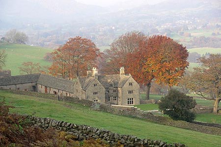
When the track turns downhill to the north towards Shatton take the public bridleway off to the right (Grid ref. SK200814). At this point it looks like you are at the same level as the end of the Ladybower reservoir which can be seen across the Hope Valley. Follow the bridleway down to Offerton Hall. There are now good views to Bamford and Hathersage.
Take the road down in front of Offerton Hall then branch off northwards (Grid ref. SK213810)on a path to the Derwent Stepping Stones - which might be passable at some time of year without having to rope up and get the waders on. This was not the case when I was last there. However there is no need to cross the river so bear left and with the river on your right walk north westwards along the river on the Derwent Valley Heritage Way to the village of Shatton.
Reaching the road through the village, turn left and take the first lane on the right, Townfield Lane (Grid ref. SK198823). This lane soon becomes a track which you follow until you reach the road leading into Brough. Just before reaching the B6049 turn off the lane onto a path on the left hand side. This passes between some houses, turns left then right, then heads off to the left towards a footpath sign in the field. From this sign continue south west and parallel to the main road past Lee House and across several fields back to Bradwell.
Maps 

| Ordnance Survey Explorer OL1 | Sheet Map | 1:25k | BUY |
| Anquet OS Explorer OL1 | Digital Map | 1:25k | BUY |
| Ordnance Survey Explorer OL24 | Sheet Map | 1:25k | BUY |
| Anquet OS Explorer OL24 | Digital Map | 1:25k | BUY |
| Ordnance Survey Digital Map Subscription | |||
| Latest Ordnance Survey Discounts | |||
Other walks nearby
| Walk 1286 | Castleton Great Ridge & Mam Tor | moderate | 8.5 miles |
| Walk 2599 | Kinder Scout and Castleton Ridge from Hope | mod/hard | 13.5 miles |
| Walk 1706 | Win Hill from Hope | easy/mod | 6.5 miles |
| Walk 3620 | Bretton Clough & Abney Moor | easy/mod | 6.0 miles |
| Walk 1270 | Abney Circular | easy/mod | 7.2 miles |
| Walk 1087 | Mam Tor & Cave Dale | moderate | 6.5 miles |
| Walk 1519 | Catleton & Speedwell Cavern Circular | easy | 4.3 miles |
| Walk 1521 | Cave Dale and Winnats Pass | easy | 4.5 miles |
| Walk 1665 | Hollins Cross & Lose Hill | easy/mod | 6.0 miles |
| Walk 3426 | Lose Hill & Hollins Cross | easy/mod | 5.0 miles |
Recommended Books & eBooks
Dark Peak Walks
 Guidebook to 40 walks in the Dark Peak area of the Peak District National Park. 35 circular routes for most abilities, from 8km to 19km, around Edale, Marsden, Fairholmes, Baslow and Castleton, including Kinder Scout and Mam Tor, and 5 longer (25km to 45km) routes highlighting the best of the Gritstone Edges, High Moorland and Deep Valleys.
More information
Walking in Derbyshire
 Walking guidebook to 60 circular day walks in Derbyshire and the Peak District. Includes the Derwent, Wye and Trent river valleys, near Derby, Matlock, Glossop, Bakewell and Ripley. Routes range from easy to moderate and are between 4 and 14km (2 to 10 miles). Walks focus on places of interest, from Stone Age forts to castles to grand estates.
More information
