Cave Dale and Winnats Pass from Castleton
Peak District Walk
Nat Park - Peak District - Great Ridge Castleton
County/Area - Derbyshire
Author - Lou Johnson
Length - 4.5 miles / 7.3 km Ascent - 800 feet / 242 metres
Time - 3 hours 0 minutes Grade - easy
Walk Route Description
Click image to visit gallery of 6 images.
Castleton offers some excellent walking with many routes radiating from the village with many walkers immediately drawn to the Castleton Ridge to the north. This Peak District walk takes you south and crosses some typical limestone scenery, providing some good views across the valley to Castleton's Great Ridge. There is a large pay and display car park adjacent to the Tourism Information Centre at grid ref. SK149829. There are plenty of opportunities for refreshment in the village either before you start the walk or after you have returned.
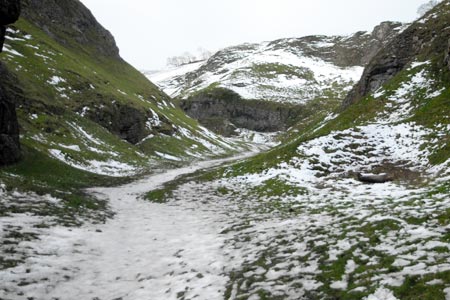
Exit the car park and turn left along Buxton Road and walk as far as the T-junction. Turn right here along Back Street which leads to the Market Place. Bear left here and a short distance ahead you will see a footpath sign on your right (grid ref SK150827). This path climbs quite steeply at first and leads you into Cave Dale with Peveril Castle perched high above you on your right. The route is never in doubt as you follow this typical limestone dale south. This section of the route follows the Limestone Way.
Reaching a junction of paths (grid ref. SK135813), leave the Limestone Way and turn right along a track. After 300 metres the track veers right and continues across undulating country passing Rowter Farm on your right. The views from this track are good with Mam Tor and the Castleton Ridge of particular note. Reaching a road (grid ref. SK126826) take the signed footpath opposite across a field (rough pasture with quarries). Just before reaching the next road (grid ref. SK125831) bear sharp right on the footpath leading south east. This path leads to a road (grid ref. SK127830).
Cross the road and take the footpath opposite, passing Winnats Head Farm on your right, to reach the road at the top of Winnats Pass (grid ref. SK130828). Turn left down the road. Note there is a path on the grass on the left hand side of the road and you can enjoy the rugged limestone crags as you descend towards Speedwell Cavern.
You have two options from here. Either follow the main road back into the centre of Castleton and the car park. There is a good footpath all the way into the village. Or you can avoid the road walking by taking the footpath that leaves the road on your right at grid ref. SK139827 and leads across fields into the village.
Maps 

| Ordnance Survey Explorer OL1 | Sheet Map | 1:25k | BUY |
| Anquet OS Explorer OL1 | Digital Map | 1:25k | BUY |
| Ordnance Survey Digital Map Subscription | |||
| Latest Ordnance Survey Discounts | |||
Other walks nearby
| Walk 1688 | Old Dam & Sparrowpit from Mam Nick | moderate | 9.0 miles |
| Walk 1286 | Castleton Great Ridge & Mam Tor | moderate | 8.5 miles |
| Walk 2599 | Kinder Scout and Castleton Ridge from Hope | mod/hard | 13.5 miles |
| Walk 1706 | Win Hill from Hope | easy/mod | 6.5 miles |
| Walk 2522 | Rushup Edge & Edale from Mam Nick | moderate | 7.0 miles |
| Walk 1368 | Mam Tor, Upper Booth & Rushup Edge | moderate | 7.0 miles |
| Walk 1831 | Mam Tor & Hollins Cross from Mam Nick | easy | 3.0 miles |
| Walk 1080 | Shatton Moor and Offerton | easy/mod | 7.5 miles |
| Walk 1159 | Grindsbrook & Edale Head | moderate | 7.5 miles |
| Walk 1264 | Rushup Edge & Crowden Tower | moderate | 10.0 miles |
Recommended Books & eBooks
Walking in Derbyshire
 Walking guidebook to 60 circular day walks in Derbyshire and the Peak District. Includes the Derwent, Wye and Trent river valleys, near Derby, Matlock, Glossop, Bakewell and Ripley. Routes range from easy to moderate and are between 4 and 14km (2 to 10 miles). Walks focus on places of interest, from Stone Age forts to castles to grand estates.
More information
Walking in the Peak District - White Peak East
 Guidebook describing 42 half-day and day walks in the limestone landscapes of Derbyshire's White Peak, part of the Peak District National Park. One of two volumes, this book covers the east of the region, with potential bases including Bakewell, Eyam, Castleton, Birchover, Matlock and Wirksworth.
More information
