Stanage Edge from Dennis Knoll
Peak District Walk
Nat Park - Peak District - Gritstone Edges Higger Tor
County/Area - Derbyshire
Author - Lou Johnson
Length - 7.0 miles / 11.4 km Ascent - 620 feet / 188 metres
Time - 4 hours 10 minutes Grade - moderate
Walk Route Description
Click image to visit gallery of 6 images.
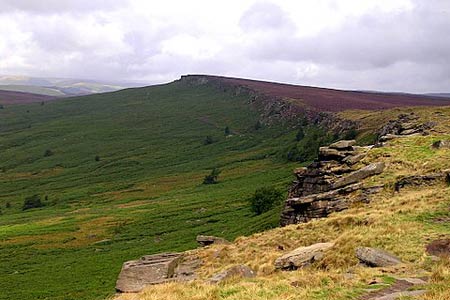
Less popular than some parts of the Dark Peak, this area still has some good walking country. The Peak District walk described below is ideal for a half day excursion and could easily be extended if required. You will be surprised by the spacious feel to the scenery above Bamford Edge. Open moorland and rolling hills, normally unseen from the valley roads, merge together backed by the gritstone forming Stanage Edge. Parking was easy, we used the spaces by the Dennis Knoll Plantation (grid ref. SK 228843) but there are other parking areas along the road running parallel and below the edge.
Following the road east and then south-east we drew level with the Stanage Plantation on our left. Taking the footpath we headed up to the edge with the scenery improving rapidly as we gained height. Clambering on to the main edge we continued east to the Stanedge Pole where views across the City of Sheffield and down to Redmires Reservoirs are on offer.
Returning in south-westerly direction to the Edge we treated the extensive boggy ground with caution. Even so wet feet were unavoidable. Regaining the edge we worked our way over the High Neb (summit point of Stanage Edge) continuing past the Crow Chin and down to the disused quarry at Stanage End. The Edge provides easy walking with good views west - including all the high ground of Kinder and Bleaklow.
Turning back on ourselves (grid ref. SK 228870) we left the ridge for lower ground using the path running parallel to our outward route. Scatted below the edge are many discarded millstones. Once quarried and finished in this area, the finished and half-finished discards show how quickly the market collapsed. Return to your car is a simple matter of navigation.
Maps 

| Ordnance Survey Explorer OL1 | Sheet Map | 1:25k | BUY |
| Anquet OS Explorer OL1 | Digital Map | 1:25k | BUY |
| Ordnance Survey Digital Map Subscription | |||
| Latest Ordnance Survey Discounts | |||
Other walks nearby
| Walk 2548 | Stanage Edge from Hathersage | moderate | 8.5 miles |
| Walk 2588 | Win Hill & Hope Cross | moderate | 7.5 miles |
| Walk 1541 | Redmire, Stanage & Ughill Moor circular | moderate | 13.0 miles |
| Walk 3540 | The Derwent Edge from Cutthroat Bridge | moderate | 10.0 miles |
| Walk 1580 | Redmires Reservoir | easy | 2.5 miles |
| Walk 2235 | Bamford & Stanage Edges | moderate | 9.9 miles |
| Walk 2516 | Moscar, Dale Dike & Shrines Reservoirs | easy/mod | 7.0 miles |
| Walk 2629 | Stanage Edge, Redmires & Hallam Moors | easy/mod | 8.5 miles |
| Walk 1479 | Burbage Moor & Redmires from near Ringinglow | easy/mod | 9.8 miles |
| Walk 1270 | Abney Circular | easy/mod | 7.2 miles |
Recommended Books & eBooks
Walking in the Peak District - White Peak East
 Guidebook describing 42 half-day and day walks in the limestone landscapes of Derbyshire's White Peak, part of the Peak District National Park. One of two volumes, this book covers the east of the region, with potential bases including Bakewell, Eyam, Castleton, Birchover, Matlock and Wirksworth.
More information
Walking in Derbyshire
 Walking guidebook to 60 circular day walks in Derbyshire and the Peak District. Includes the Derwent, Wye and Trent river valleys, near Derby, Matlock, Glossop, Bakewell and Ripley. Routes range from easy to moderate and are between 4 and 14km (2 to 10 miles). Walks focus on places of interest, from Stone Age forts to castles to grand estates.
More information
