Glas Bheinn & Eas a' Chual Aluinn (waterfall)
Highland Walk
County/Area - Highland - Northern Highland
Author - Lou Johnson
Length - 8.5 miles / 13.8 km Ascent - 2900 feet / 879 metres
Time - 7 hours 10 minutes Grade - mod/hard
Maps 

| Ordnance Survey Explorer 442 | Sheet Map | 1:25k | BUY |
| Anquet OS Explorer 442 | Digital Map | 1:25k | BUY |
| Ordnance Survey Landranger 15 | Sheet Map | 1:50k | BUY |
| Anquet OS Landranger 15 | Digital Map | 1:50k | BUY |
Walk Route Description
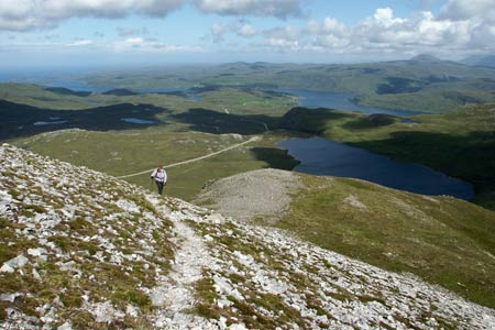
Click image to visit gallery of 12 images.
This walk explores a stunningly beautiful area of country to the east of the A894 a few miles south of Kylesku village. It is not a route to be completed in poor visibility unless your micro-navigation skills are perfect. The route starts with a steep climb onto the north ridge of Glas Bheinn before continuing to its summit where superb views of the mountains of Southerland. Continuing the walk descends to a col where a stalker's path is joined to traverse wild country with many small lochans and complex topography to reach the Eas a' Chual Aluinn. The route is completed by continuing through interesting and complex topography back to the start. It is worth noting that there are some sections where you traverse wet ground and appropriate footwear in recommended.
The start is alongside the A894 a few miles south of Kylesku roughly opposite the southern end of Loch na Gainmhich where a path joins the road (grid ref. NC238284). Walk east along this path to reach a path junction in less than 200 metres. Turn right and climb gently with the slopes of Glas Bheinn rising ahead to your left. Continue along this path until you are opposite a grassy section on the hillside that runs steeply up onto of the main ridge of Glas Bheinn (approx. grid ref. NC239274). Head steeply uphill and make surprisingly rapid progress to emerge onto the ridge. The view across the main road to Quinag is immediately impressive.
Turn south along the ridge soon reaching the summit, which is domed yet still offers some grand views. To the north and east of the summit are deep coires and these need to be avoided in the descent. So leave the summit and walk southeast taking care not to bear too far to your left into Coire Gorm. There is evidence of a path as you reach the top of a narrowing ridge leading down to Bealach na h-Uidhe. As you descend you get you a good view northeast into the terrain that is about to be traversed.
At the bealach turn left on the stalkers path. At first the path strikes north before looping back on itself to pass above a lochan. From now on your micro-navigation skills need to be good! Using the 1:25000 map, make sure you are know exactly where you are at all times. Generally speaking the path ahead is clear on the ground but there are a couple of places where wet ground is crossed and the path loses definition. These are the places where going astray is easily done. Assuming all is well you will reach the pair of lochans at grid ref. NC279270. The path goes between the lochans to reach a path junction. Go left here and continue to the ford and path junction below Loch Poll Amhluaidh (grid ref. NC273277). From here you have the option of making an out and back visit to the Eas a' Chual Aluinn (waterfall).
After visiting the waterfall continue on the main path climbing steadily to eventually skirt Loch Bealach a' Bhuirich on its northern shores. The path then follows the stream from this loch. There is a path junction at grid ref. NC250288 where you will need to turn west (left). Vigilance is required to find this as the actual junction is indistinct. If in doubt choose the best line and descend towards the path running along the southern shore of Loch na Gainmhich where you will pick up the path back to the start.
Other walks nearby
| Walk 1317 | Sail Gharbh (Quinag) | moderate | 5.4 miles |
| Walk 3272 | Conival & Ben More Assynt from Inchnadamph | hard | 11.0 miles |
| Walk 1319 | The Bone Caves of Inchnadamph | easy | 3.0 miles |
| Walk 1769 | Suilven (North-western approach) | hard | 12.0 miles |
| Walk 1316 | Falls of Kirkaig | easy | 5.8 miles |
| Walk 1312 | Achmelvich Bay and Alltanabradhan | easy | 3.0 miles |
| Walk 2274 | Cul Mor from Knockan Crag | mod/hard | 8.5 miles |
| Walk 3261 | Handa Island - Scottish Wildlife Trust | easy | 4.0 miles |
| Walk 2529 | Stac Pollaidh Circular | easy/mod | 2.8 miles |
| Walk 1017 | Stac Pollaidh | easy/mod | 3.0 miles |
Recommended Books & eBooks
Skye's Cuillin Ridge Traverse
 This 2-volume set provides all the information required to complete the main ridge traverse on Skye's Black Cuillin. Strategy, gear, training, navigation and logistics are covered, and 10 classic scrambles are described. A lightweight second guidebook gives the scrambler detailed maps, topos and route description for the ridge traverse itself.
More information
Walking in Torridon
 This guidebook contains 52 day walks in Torridon, a remote and much-loved area of the Scottish Highlands. Based around Shieldaig and Slioch, the routes are split into 3 sections: easy walks, long and high level walks and mountain ascents over 2000ft including 9 Munros, and 5 outline suggestions for major ridge walks.
More information
Messaging & Social Media
Message Walking Britain and follow the latest news.

Mountain Weather
Stay safe on the mountains with detailed weather forecasts - for iOS devices or for Android devices.