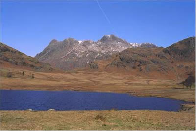
Lingmoor Fell from Blea Tarn
Lake District Walk
Nat Park - Lake District - Lake District Southern Fells
Wainwrights - Lingmoor Fell
County/Area - Cumbria
Author - Lou Johnson
Length - 8.0 miles / 13 km Ascent - 1400 feet / 424 metres
Time - 5 hours 20 minutes Grade - moderate
Walk Route Description
Click image to visit gallery of 3 images.
Parking in the small car park (grid ref. NY 296042) by Blea Tarn the intention was to climb Pike o' Blisco. After twenty minutes or so we turned back because the path was obliterated by snow and ice. The obvious choice was Lingmoor Fell which was free of deep snow but still offered the prospect of excellent views in the bright winter sunshine.
To start this Lake District walk follow the path from the car park walk along the southern and western shores of the tarn to reach the road down into Great Langdale beneath the imposing crags of Side Pike. This wonderful miniature "mountain" can also be included in the walk although on this occasion we skirted beneath it and climbed steeply up to the col beneath its eastern face. From here it is a matter of following the ridge wall to the summit of Lingmoor Fell. It is a wonderful walk with excellent views all around you. Of particular note are the Tilberthwaite Fells with Wetherlam looking particularly ominous to the south. The Langdale Pikes, Bowfell and the Crinkle Crags and the blue waters of Lake Windermere all competed for our attention.
From the summit cairn continue south easterly towards Dale End Farm. This is not seen until you have lost considerable height and care is needed to select the right path. All is not lost if you go too far left - you arrive in Elterwater rather than Little Langdale and a return to Blea Tarn can be made via a number of routes.
From Dale End take the farm track and cross the main lane in Little Langdale heading for High Birk Howe and Slater's Bridge. The bridge is worth a visit in its own right and is a remarkable piece of workmanship. Continue west along the stony track towards Greenburn, taking the right fork to Fell Foot Farm. Follow the Wrynose Pass road round to the left in front of Castle Howe and then carefully pick your way across Blea Moss as you head north to Blea Tarn. This is a delightful path, culminating with a short stretch alongside Bleamoss Beck as it tumbles down some pretty falls.
One particular event of note was that this was the first time we had witnessed hounds racing on the fells. Following what we guessed was an aniseed trail they completed the course from Little Langdale to the summit of Lingmoor Fell and back down in about fifteen minutes! The hounds seemed to manage this with enough energy to bark all the way around the course!
Maps 

| Ordnance Survey Explorer OL6 | Sheet Map | 1:25k | BUY |
| Anquet OS Explorer OL6 | Digital Map | 1:25k | BUY |
| Ordnance Survey Digital Map Subscription | |||
| Latest Ordnance Survey Discounts | |||
Other walks nearby
| Walk 1132 | Great Langdale & The Crinkle Crags | mod/hard | 7.0 miles |
| Walk 1157 | Bowfell and Esk Pike | hard | 8.8 miles |
| Walk 2037 | Bowfell & Rosset Pike via the Climber's Traverse | hard | 7.5 miles |
| Walk 2818 | Bowfell Circular from Great Langdale | mod/hard | 7.0 miles |
| Walk 1739 | Crinkle Crags and Bowfell (Oxendale Horseshoe) | hard | 7.8 miles |
| Walk 1134 | Wetherlam and The Carrs | mod/hard | 10.8 miles |
| Walk 2270 | Tilberthwaite and Holme Fell Little Langdale | easy/mod | 5.5 miles |
| Walk 1207 | Great & Little Langdales | moderate | 8.5 miles |
| Walk 2042 | The Langdale Pikes with an ascent of Jack's Rake | very hard | 6.3 miles |
| Walk 2073 | Harrison Stickle, Pike o'Stickle & Rosset Pike | moderate | 8.3 miles |
Recommended Books & eBooks
Walking the Lake District Fells - Wasdale
 Part of the Walking the Lake District Fells series, this guidebook covers a wide range of routes to 25 Lakeland summits that can be climbed from the Wasdale, Eskdale and Ennerdale valleys, with highlights including Scafell Pike, Great Gable and Pillar. Suggestions for longer ridge routes are also included.
More information
Great Mountain Days in the Lake District
 An inspirational guidebook to 50 challenging walks on the high fells of the Lake District. The graded circular routes, between 4 and 14 miles in length, cover classic Lakeland summits like Fairfield, Scafell Pike, Great Gable and Blencathra, to the lesser-known High Spy, King's How and Brund Fell.
More information
