Great Langdale & The Crinkle Crags
Lake District Walk
Nat Park - Lake District - Lake District Southern Fells
Wainwrights - Crinkle Crags
County/Area - Cumbria
Author - Lou Johnson
Length - 7.0 miles / 11.4 km Ascent - 2850 feet / 864 metres
Time - 6 hours 20 minutes Grade - mod/hard
Walk Route Description
Click image to visit gallery of 3 images.
Despite its obvious popularity this remains one of Lakeland's great walks. Sufficiently challenging yet not too arduous it provides walkers with great scenery supplemented with that unique mountain "feel". Like many walks in the area it starts from the Old Dungeon Ghyll Hotel in Langdale (grid ref. NY 286060) where parking can be hard to find if you arrive too late on a fine day!
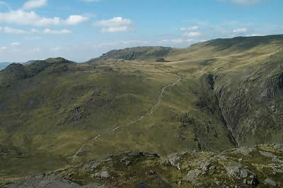
To start this Lake District walk, exit the car park and return to the lane and head west taking the track to Stool End farm. Go through the farm and keep left at two footpath junctions to join the path that heads into spectacular Oxendale. Cross the first footbridge on your left and head steeply upwards towards Red Tarn. This climb appears to be a hard work but with ever improving views and a good path it is surprisingly easy and arrival at the small tarn is accomplished quite quickly.
Turn right at the Tarn and climb steadily on a wide path to cross the head of Browney Gill (an alternative and infinitely more difficult approach to the Crinkle Crags!). Continue with the broad path as its skirts Great Knott, which is a perfect short diversion with a superb view. The onward route is obvious and one soon reaches rockier ground as the first summit of the Crinkle Crags is reached.
This is a mountain to enjoy at leisure being a complex series of six summits (including Shelter Crags) which offer ever changing panoramas in all directions. In addition there are some spectacular views down into the upper reaches of Oxendale which more than justify the effort expended in the ascent. Apart from the "bad step" on the approach to the second Crinkle (which can be avoided by taking the path that heads left) there are no technical problems to be overcome at any point on the ridge. Navigation is fairly simple in good weather although it could be a confusing area if visibility is poor (I would argue it deserves to be traversed in sunshine). Continue along the ridge choosing the path that keeps to the highest ground.
Descent to Three Tarns is something of anti-climax although the sight of Bowfell directly ahead will help dispel any negative thoughts! Reaching the small tarns turn right to follow the recently upgraded path that descends over the Band to Stool End Farm from where it is an easy level stroll back to the Old Dungeon Ghyll car park.
Maps 

| Ordnance Survey Explorer OL6 | Sheet Map | 1:25k | BUY |
| Anquet OS Explorer OL6 | Digital Map | 1:25k | BUY |
| Ordnance Survey Digital Map Subscription | |||
| Latest Ordnance Survey Discounts | |||
Other walks nearby
| Walk 1207 | Great & Little Langdales | moderate | 8.5 miles |
| Walk 2042 | The Langdale Pikes with an ascent of Jack's Rake | very hard | 6.3 miles |
| Walk 2073 | Harrison Stickle, Pike o'Stickle & Rosset Pike | moderate | 8.3 miles |
| Walk 1736 | Langdale Pikes and High Raise FROM New Dungeon Ghyll | mod/hard | 6.1 miles |
| Walk 1144 | Lingmoor Fell | moderate | 8.0 miles |
| Walk 1171 | Pike o' Blisco | moderate | 5.0 miles |
| Walk 2582 | Pike o' Stickle, Harrison Stickle & Pavey Ark | moderate | 6.0 miles |
| Walk 3508 | The Crinkle Crags from Wrynose Pass | easy/mod | 5.0 miles |
| Walk 1134 | Wetherlam and The Carrs | mod/hard | 10.8 miles |
| Walk 2270 | Tilberthwaite and Holme Fell Little Langdale | easy/mod | 5.5 miles |
Recommended Books & eBooks
Walking the Lake District Fells - Keswick
 Part of the Walking the Lake District Fells series, this guidebook covers a wide range of routes to 30 Lakeland summits that can be climbed from Keswick, Whinlatter, Bassenthwaite, Caldbeck, Mungrisdale and Threlkeld, with highlights including Skiddaw and Blencathra. Includes suggestions for longer ridge routes.
More information
Lake District: Low Level and Lake Walks
 This guidebook describes 30 of the best low-level walks in the Lake District. From delightful wooded glades and sparkling tarns, to waterfalls and glacier-carved valleys towered over by craggy mountains. The walks described aim to seek out the best walking that the lower areas of the Lake District have to offer.
More information
