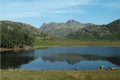
Pike o' Blisco from Blea Tarn
Lake District Walk
Nat Park - Lake District - Lake District Southern Fells
Wainwrights - Pike o' Blisco
County/Area - Cumbria
Author - Lou Johnson
Length - 5.0 miles / 8.1 km Ascent - 1800 feet / 545 metres
Time - 4 hours 20 minutes Grade - moderate
Walk Route Description
Click image to visit gallery of 5 images.
Blea Tarn situated between Little and Great Langdales at the foot of Pike o' Blisco is one of my favourite places in the Lake District. Surrounded by mountains the view across the water to the Langdale Pikes is perfect especially in morning sunshine. This Lake District walk is an out and back excursion to the superb summit of Pike o' Blisco and for most of the way is over good paths.
I parked in the small parking area just off the road that runs on the east side of Blea Tarn (grid ref. NY296042). From here take the signed footpath along the southern shore of the Tarn with the wonderful view to the Langdale Pikes on your right. Continue down to the small wood, cross the bridge and turn right along the path that skirts the western shores of the tarn. Heading north this path leads back to the road linking Great and Little Langdales just below the shapely outline of Side Pike, which is reminiscent of a miniature Langdale Pike.
Do not exit to the road but instead bear half left across a boggy area and just before you start to lose height turn left to contour across the fellside. In summer the route follows a broad grassy path that leads to a narrower path through bracken. Neither losing or gaining height you cross two becks on of which might cause problems if in spate to reach the main path coming up from Great Langdale. Turning left onto this paved path you have twenty minutes of steady climbing before the walk becomes easier.
As you climb there are excellent views behind over Great Langdale to the shapely Pikes. Eventually the path levels off and continues across a broad area of open fell with the craggy summit of Pike o' Blisco ahead. Surrounded by low rock walls, the summit area is a scramblers paradise although all the "hand work" can be avoided by careful route selection.
In places the route of the path is not too clear but a few small cairns help direct you to the topmost point. On the day we did this walk, a large new cairn was being built (see Site Magazine for details). Whatever your views on cairns, the summit is a great place to stay a while. In every direction there are grand fells including the Crinkle Crags, Bowfell, the Carrs, Wetherlam and the Langdale Pikes. Having absorbed the view return to Blea Tarn by the outward route having filled a pleasant half day with a mountain excursion.
Maps 

| Ordnance Survey Explorer OL6 | Sheet Map | 1:25k | BUY |
| Anquet OS Explorer OL6 | Digital Map | 1:25k | BUY |
| Ordnance Survey Digital Map Subscription | |||
| Latest Ordnance Survey Discounts | |||
Other walks nearby
| Walk 1132 | Great Langdale & The Crinkle Crags | mod/hard | 7.0 miles |
| Walk 1157 | Bowfell and Esk Pike | hard | 8.8 miles |
| Walk 2037 | Bowfell & Rosset Pike via the Climber's Traverse | hard | 7.5 miles |
| Walk 2818 | Bowfell Circular from Great Langdale | mod/hard | 7.0 miles |
| Walk 1739 | Crinkle Crags and Bowfell (Oxendale Horseshoe) | hard | 7.8 miles |
| Walk 1134 | Wetherlam and The Carrs | mod/hard | 10.8 miles |
| Walk 2270 | Tilberthwaite and Holme Fell Little Langdale | easy/mod | 5.5 miles |
| Walk 1207 | Great & Little Langdales | moderate | 8.5 miles |
| Walk 2042 | The Langdale Pikes with an ascent of Jack's Rake | very hard | 6.3 miles |
| Walk 2073 | Harrison Stickle, Pike o'Stickle & Rosset Pike | moderate | 8.3 miles |
Recommended Books & eBooks
Outdoor Adventures with Children - Lake District
 Guidebook to 40 outdoor adventures in the Lake District with children under 12, including walking, cycling, orienteering, paddling, boating, hostelling and more. Graded activities for varying age ranges or for families with children of different ages.
More information
The Cumbria Way
 A guidebook to the 73 mile Cumbria Way, an easy long-distance walk though the heart of the Lake District National Park, from Ulverston in the south to Carlisle in the north, with good transport links to either end. The route is largely low-level but this guide offers alternative mountain days to climb some of the famous fells en route.
More information
