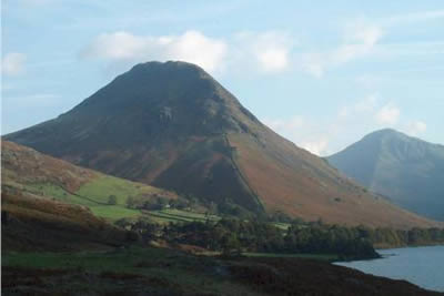
Yewbarrow from Wasdale
Lake District Walk
Nat Park - Lake District - Lake District Western Fells
Wainwrights - Yewbarrow
County/Area - Cumbria
Author - Lou Johnson
Length - 4.5 miles / 7.3 km Ascent - 1985 feet / 602 metres
Time - 4 hours 10 minutes Grade - moderate
Walk Route Description
Click image to visit gallery of 7 images.
Despite its modest height, Yewbarrow has a great visual impact on anyone heading towards Wasdale Head. Strategically situated on the northern shores of the lake, its wonderful shape and steep crags are an inspiring sight. This Lake District walk is short, full of interest and if you only have time for one walk in Wasdale this is a must. It provides great views all the way round, has some scrambling and a short section of ridge walking.
The small car park alongside Over Beck bridge (grid ref. NY167068) fills quickly so an early start is recommended. Take the path leaving the car park at the northern end and make for the stile at the foot of the steep grassy path that leads upwards to Bell Rib, the crags of Yewbarrow's southern prow. The ascent is steep but has the advantage that height is gained quickly with rapidly improving views across to the Scafells.
The path leaves the wall and traverses across the fellside. Take the uppermost path (the lower one leads directly to Dore Head) and head towards Dropping Crag to the right of which is a clearly defined gully. Some scrambling is required although there are good foot and hand holds. Reaching the top of the scramble the ascent becomes less steep although the path is badly eroded. To take in the Great Door with its spectacular view, you should keep to the lower of the many paths on this section.
All the hard work is well rewarded on reaching Great Door with a spectacular gully heading down to Wast Water. Across Wasdale can be seen the Scafells with notorious Mickledore clearly seen. The difficulties are nearly over and the onward route continues climbing following the ridge to lead easily to the summit of Yewbarrow. By now the view has become superb with Kirk Fell, Great Gable, the Scafells, Pillar and Red Pike the dominant peaks in view.
After a kilometre of easy walking along the crest you reach the subsidiary northern summit above Stirrup Crag. It is well worth spending some time here to take in the mountain panorama. From here the view down into Mosedale is very spectacular with Pillar looking massive at the head of the Dale. From here the path drops steeply down to Dore Head with a couple of short sections of easy scrambling and some annoying loose underfoot conditions in places. Note - some rock falls have blocked the path on this descent and a diversion is necessary. Care is needed. (09/05/2006).
All that is left is an easy downhill walk back to Over Beck bridge. Rather than follow the main path we chose to cross Over Beck above the waterfall marked on the OS 1:25000 map and then take the path beside the Beck. This provides a much more pleasant way down than the main well-used path which can be boggy in places.
Maps 

| Ordnance Survey Explorer OL6 | Sheet Map | 1:25k | BUY |
| Anquet OS Explorer OL6 | Digital Map | 1:25k | BUY |
| Ordnance Survey Digital Map Subscription | |||
| Latest Ordnance Survey Discounts | |||
Other walks nearby
| Walk 1126 | Mosedale Horseshoe | hard | 11.5 miles |
| Walk 1246 | Black Sail Pass & Beck Head | moderate | 5.5 miles |
| Walk 2034 | Scafell from Wasdale Head | hard | 6.5 miles |
| Walk 2800 | The Scafells via Piers Gill from Wasdale Head | mod/hard | 7.5 miles |
| Walk 2900 | Pillar (by the High Level Path) from Wasdale | mod/hard | 8.0 miles |
| Walk 2718 | The Scafells from Wasdale Head | mod/hard | 9.0 miles |
| Walk 1303 | Buckbarrow, Seatallan & Middle Fell from Loweswater | moderate | 7.0 miles |
| Walk 3489 | Scale Bridge & Low Wood from Greendale | easy | 5.2 miles |
| Walk 3485 | High Birkhow & Low Wood from Wast Water | easy | 4.2 miles |
| Walk 2355 | Blea Tarn & Eskdale Green | easy/mod | 6.5 miles |
Recommended Books & eBooks
Walking the Lake District Fells - Patterdale
 Part of the Walking the Lake District Fells series, this guidebook covers a wide range of routes to 35 Lakeland summits that can be climbed from Ambleside, Grasmere and Patterdale and the Thirlmere and Ullswater valleys, with highlights including Helvellyn and Fairfield. Suggestions for longer ridge routes are also included.
More information
Hadrian's Wall Path
 Hadrians Wall Path guidebook to walk the 84 mile National Trail. Described in both directions, the main description is west to east between Bowness-on-Solway and Wallsend, Newcastle, with extensions to Maryport and South Shields. With extensive historical information related to this World Heritage site and separate 1:25,000 OS map booklet included.
More information
