Cadair Idris Minffordd Path
Snowdonia/Eryri Walk
Nat Park - Snowdonia - Cadair Idris
County/Area - Gwynedd
Author - Lou Johnson
Length - 6.0 miles / 9.8 km Ascent - 2885 feet / 874 metres
Time - 5 hours 50 minutes Grade - mod/hard
Walk Route Description
Click image to visit gallery of 5 images.
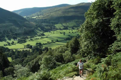
Cadair Idris is one of the great mountains of Snowdonia (Eryri) and its proximity to the sea is one of its attractions. However on closer inspection it is a mountain area of high quality with numerous crags and cwms and worth more than one visit. This route starts at the car park at Minffordd (grid ref. SH732115) and follows a well maintained path for most of the ascent. (See walk 1172 for details of the northern ascent route using the Pony Path)
To start this Snowdonia (Eryri) walk, leave the car park on the signed path. Initially you climb steeply through beautiful woodland gaining height quickly. The path is flagged and progress is easy. Quite soon you are above the trees and the view south to Corris and the Tarren Mountains opens out. Continuing to climb you enter a broad valley and stay with the main path which turns west to head for the pointed outline of Craig Cwm Amarch.
The view ahead becomes more dramatic especially when you are able to see the waters of Llyn Cau which is located in a superb amphitheatre of crags and mountains. The path turns south to climb onto the ridge leading to the summit of Craig Cwm Amarch (791m.) with excellent views in all directions.
Reaching the summit cairn perched high above the waters of Cwm Cau you could be excused for not wanting to go any further. However Cadair Idris beckons although its shape is none too inspiring! Descend to the col on the northern side of Craig Cwm Amarch and follow the path through rocks to reach the summit area of Cadair Idris. Besides a trig column there are many other cairns and a small stone-built shelter. The views are superb especially to the north.
Head east off the summit and follow the ridge path that heads to Mynydd Moel. Either continue to this summit and then follow the path south alongside the fence or take the descending path that forks right about 500 metres from the summit of Cadair Idris. Both routes provide problem free descents and join together to follow a path that is being improved by National Park staff. The descent offers good views of the outward route which it joins just above the tree-line. The fun has now been taken out of crossing the stream, with a bridge provided in 2008.
Maps 

| Ordnance Survey Explorer OL23 | Sheet Map | 1:25k | BUY |
| Anquet OS Explorer OL23 | Digital Map | 1:25k | BUY |
| Ordnance Survey Digital Map Subscription | |||
| Latest Ordnance Survey Discounts | |||
Other walks nearby
| Walk 2475 | The Dyfi Hills Ridge | mod/hard | 9.8 miles |
| Walk 1172 | Cadair Idris by the Pony Path | mod/hard | 11.0 miles |
| Walk 2668 | Cadair Idris, Craig Cau and Cyfrwy by the Pony Path | mod/hard | 5.3 miles |
| Walk 2570 | Cadair Idris from Llanfihangel-y-pennant | mod/hard | 10.0 miles |
| Walk 2707 | Tyrrau Mawr and Craig-y-llyn from Llanfihangel-y-pennant | moderate | 9.5 miles |
| Walk 1309 | Tarren y Gesail | moderate | 8.0 miles |
| Walk 1643 | Llanfihangel-y-pennant & Castell y Bere | easy/mod | 6.8 miles |
| Walk 3582 | Castell y Bere & Llanfihangel-y-pennant from Abergynolwyn | easy/mod | 5.7 miles |
| Walk 2334 | The Torrent Walk near Dolgellau | easy | 1.6 miles |
| Walk 1851 | Cregennen Lakes & Pared y Cefn-hir | easy/mod | 2.5 miles |
Recommended Books & eBooks
Snowdonia: 30 Low-level and easy walks - North
 Guidebook describing 30 walks in Snowdonia, Wales. Routes are mostly low level and on clear paths and showcase the region's beautiful scenery and rich history and culture. Part of a 2-volume set, this northern volume includes the Snowdon area, the Ogwen and Conwy Valleys, Betws-y-Coed, Beddgelert, Ffestiniog and the coast.
More information
Snowdonia: 30 Low-level and easy walks - South
 Guidebook describing 30 walks in Snowdonia, Wales. Routes are mostly low level and on clear paths and showcase the region's beautiful scenery and rich history and culture. Part of a 2-volume set, this southern volume includes Trawsfynydd, Bala, Dolgellau, Machynlleth, the Harlech Coast and the valleys of the Mawddach and Dyfi.
More information
