Morvah to Zennor coast
Cornwall AONB Walk
Region - Cornwall AONB
County/Area - Cornwall
Author - Lou Johnson
Length - 5.5 miles / 8.9 km Ascent - 1500 feet / 455 metres
Time - 4 hours 20 minutes Grade - moderate
Walk Route Description
Click image to visit gallery of 8 images.
This route explores some of the most dramatic coastal scenery in Cornwall and uses the South West Coast Path from Morvah to Zennor. Coastal walking is not always easy and it is worth noting the considerable ascent over the relatively short distance of this walk. Three options should be considered :-
1 - Park your car at Zennor where a small car park usually has plenty of space and catch a bus to Morvah. This is the option used for the walk description.
2 - Park you car at Morvah and walk to Zennor and catch the bus back to Morvah. Not recommended as the walk could well take much longer than anticipated and the bus service suffers from low frequency.
3 - Park you car at Zennor and follow the outward route marked on the map. In my opinion the road walking and countryside do not merit taking the extra effort involved in this option.
Assuming you take the recommended option, park in the small car park alongside the hostel in Zennor (grid ref. SW454384) and catch the bus to Morvah. The bus does not go into Zennor village but stays on the main road. Note that the bus service is infrequent and you need to check times before making plans. Alighting at Morvah the walk begins by taking the footpath on the east side of the churchyard. This leads between walls to the South West Coast Path where you turn right (east).
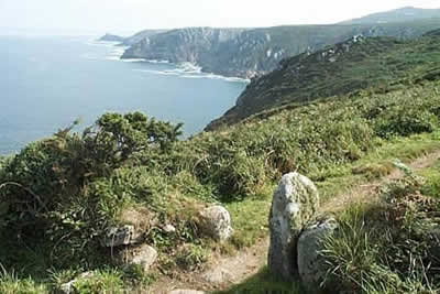
The next five miles offer some superb coastal scenery with plenty of 'ups' and 'downs'. Immediately on reaching the coast path you get a good idea of what is in store with the view ahead revealing a succession of rocky headlands. Away to right are the moors and tors of Carn Galver, which add an extra dimension to the scenic interest.
Bosigran castle, a dramatic headland, is the first major item of note. Popular with climbers and scramblers, it is a great place to stop and take in the scene. Continuing eastwards you reach Porthmeor Cove from where a steady climb out of the valley here leads you to Porthmeor Point. Ahead is a superb vista including Gurnard's Head, which provides a second convenient place for a rest.
If this is your first coastal walk on terrain of this type then you will soon realise that the headland that seemed to be "just round the corner" involves far more leg work than anticipated! This is certainly the case on the next section to Zennor Head, which takes much longer than the map might suggest. Like all good sections of path it is never tedious and there is always a surprise around the next corner.
Contouring around Carnelloe Cliff the view ahead reveals Zennor Head. This dominant headland marks the end of this coastal walk and after climbing up steps to reach a lane (grid ref. 450389) it is time to say farewell to the Coastal Path and head the short distance inland to Zennor where a pub and cafe offer refreshment.
Maps 

| Ordnance Survey Explorer 102 | Sheet Map | 1:25k | BUY |
| Anquet OS Explorer 102 | Digital Map | 1:25k | BUY |
| Ordnance Survey Digital Map Subscription | |||
| Latest Ordnance Survey Discounts | |||
Other walks nearby
| Walk 1224 | Men-an-tol & Ding Dong Mine | easy | 3.0 miles |
| Walk 2206 | St. Ives - a town stroll | easy | 1.5 miles |
| Walk 3325 | Chun Quoit & Carn Kenidjack | easy | 4.0 miles |
| Walk 2207 | Penzance - a town stroll | easy | 1.5 miles |
| Walk 3501 | Penzance to Porthcurno via Mousehole and Lamorna | moderate | 11.0 miles |
| Walk 2205 | Newlyn - a village trail | easy | 1.0 miles |
| Walk 1028 | Chun Quoit and Botallack | moderate | 8.0 miles |
| Walk 2208 | Marazion - a town stroll | easy | 1.0 miles |
| Walk 1225 | Sennen Cove & Botallack from St Just | moderate | 7.5 miles |
| Walk 2616 | The moors and hills of Penwith | moderate | 14.0 miles |
Recommended Books & eBooks
South West Coast Path Map Booklet - Minehead to St Ives
 Map of the northern section of the 630 mile (1014km) South West Coast Path National Trail. Covers the trail from Minehead to St Ives along the north Devon and Cornish coastline. This convenient and compact booklet of Ordnance Survey 1:25,000 maps shows the route, providing all of the mapping you need to walk the trail in either direction.
More information
The South West Coast Path
 Guidebook to walking the entire South West Coast Path National Trail. The route runs for 630 miles from Minehead to Poole along the north Devon, Cornish, south Devon and Dorset coastline. Divided into 45 stages, this long-distance coastal trek could be completed within 4 weeks, or walked in sections. Guide includes maps and essential information.
More information
