Hay Bluff & Twmpa Circular
Brecon Beacons/Bannau Brycheiniog Walk
Nat Park - Brecon Beacons - Brecon Beacons East
County/Area - Powys
Author - Lou Johnson
Length - 6.0 miles / 9.8 km Ascent - 1390 feet / 421 metres
Time - 4 hours 20 minutes Grade - moderate
Walk Route Description
Click image to visit gallery of 9 images.
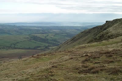
The Black Mountains form the eastern sector of the Brecon Beacons National Park and provide excellent walking with high ridges and superb edges. This walk starts from the parking area (grid ref. SO239373) at the foot of Hay Bluff and in a relatively short distance offers a taste of what can be achieved in this area.
From the parking area the first objective, Hay Bluff a steep escarpment, can be easily seen. The ascent begins across grass aiming for the rising path that can be seen on the face of the escarpment. The going is steep in places but you gain height surprisingly quickly with ever improving views over the Wye Valley to the hills and mountains of mid-Wales. Reaching the transverse path turn left and continue until you locate another path that goes sharp left. This leads without any problem to the summit of Hay Bluff, which is marked by a trig point.
After taking in the view head south west following the clear path along the edge. It is boggy in places so good footwear is essential. Ahead and across the intervening col you can see the next objective, Twmpa or Lord Hereford's Knob. Descending to reach the road at Gospel Pass you climb steeply at first before the gradient eases for an easy ascent to the summit of Twmpa. A small cairn marks the top and there are good views in most directions.
Descend from Twmpa's summit southwest towards to Rhos Dirion, the next peak along the edge. As soon as the path levels off look out for a clear path that comes in from the left. Turn down this path descending onto the grassland at the bottom of the edge. Continue to the boundary fence (grid ref. 220356) where you join a clear track. This track heads northwest before swinging southeast to join a metalled lane. Turn right along this quiet lane to cross a ford and continue northeast to reach the parking area after just over a mile.
Maps 

| Ordnance Survey Explorer OL13 | Sheet Map | 1:25k | BUY |
| Anquet OS Explorer OL13 | Digital Map | 1:25k | BUY |
| Ordnance Survey Digital Map Subscription | |||
| Latest Ordnance Survey Discounts | |||
Other walks nearby
| Walk 1957 | Cefn Hill & Vagar Hill - Golden Valley | easy/mod | 5.5 miles |
| Walk 1660 | Craswall Priory & Hay Bluff | easy/mod | 6.0 miles |
| Walk 3204 | Hay Bluff & Twmpa | moderate | 10.3 miles |
| Walk 2935 | Llanthony Priory from Capel-y-ffin | easy/mod | 7.7 miles |
| Walk 1950 | Golden Valley - Hardwicke to Dorstone | moderate | 11.4 miles |
| Walk 2179 | Merbach Hill | easy/mod | 6.5 miles |
| Walk 1106 | Waun Fach | mod/hard | 7.5 miles |
| Walk 2065 | Waun Fach & Y Grib from Pengenfford | moderate | 6.5 miles |
| Walk 1237 | Cwmyoy & Hatterrall Hill from Llanthony Priory | moderate | 10.0 miles |
| Walk 3203 | Vale of Ewyas from Llanthony Abbey | moderate | 10.7 miles |
Recommended Books & eBooks
The Cambrian Way
 Guidebook to the Cambrian Way, a challenging three-week mountain trek through Wales from Cardiff to Conwy. The 470km un-waymarked route is presented from south to north. Often sticking to long, beautiful ridgelines, it crosses wild and rugged terrain and visits many of Wales's highest mountains, including Snowdon.
More information
Walking in Carmarthenshire
 Guidebook to 30 walking routes (2 to 10 miles) in Carmarthenshire, south Wales, including sections of Carmarthenshire Coast Path. Walks for all abilities, including coastal, river, forest and hill walks in Cambrian Mountains, Tywi Valley, Y Mynydd Du (Black Mountains) and Brecon Beacons. Easy access from Bristol, Cardiff and Swansea.
More information
