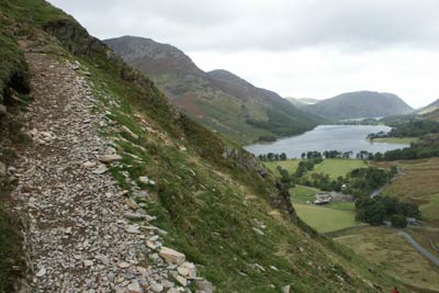
Fleetwith Pike & Haystacks from Gatescarth
Lake District Walk
Nat Park - Lake District - Lake District Western Fells
Wainwrights - Fleetwith Pike, Haystacks
County/Area - Cumbria
Author - Lou Johnson
Length - 5.5 miles / 8.9 km Ascent - 2500 feet / 758 metres
Time - 5 hours 20 minutes Grade - moderate
Walk Route Description
Click image to visit gallery of 12 images.
This is a relatively short Lake District horseshoe walk starting from Gatescarth at the foot of Honister Pass on the Buttermere side. Despite being short in distance, the route offers an outstanding view of Lakeland scenery including many of the high fells and some its lakes.
There is a small car park at Gatescarth Farm (Grid ref. NY 195150). The first objective, Fleetwith Pike, looks a daunting prospect from the car park yet its ascent is interesting and remarkably quick to achieve. Exit the car park and turn left along the road towards Seatoller exiting almost immediately to join the path that heads towards the foot of Fleetwith Pike. The climb starts immediately and passes a memorial cross to climb quite steeply at times towards the summit. There are numerous excuses to pause awhile for the improving retrospective view back towards Buttermere and the surrounding fells.
Reaching the summit cairn leave by the main path heading roughly east to take the first right fork. This leads without too much confusion to the stone hut at the foot of the old slate quarry incline below Dubs Quarry (Grid ref. NY 209134). From here pick up the main path to Haystacks, taking care not to return on the direct path to Gatescarth! The path descends to cross a stream before climbing up to Blackbeck Tarn with Great Gable forming a wonderful backdrop. Continue on the path walking along the east shore of Innominate Tarn to reach the summit of Haystacks with its many crags and a small tarn.
Descend west off the summit taking care to locate the path and descend to Scarth Gap. Turn right here and descend to Peggy's Bridge (Grid ref. NY 190148) to reach Gatescarth Farm and the starting point.
Maps 

| Ordnance Survey Explorer OL4 | Sheet Map | 1:25k | BUY |
| Anquet OS Explorer OL4 | Digital Map | 1:25k | BUY |
| Ordnance Survey Digital Map Subscription | |||
| Latest Ordnance Survey Discounts | |||
Other walks nearby
| Walk 2642 | Buttermere Horseshoe | very hard | 14.0 miles |
| Walk 1732 | Coledale and Newlands circular from near Buttermere | hard | 9.0 miles |
| Walk 1011 | Knott Rigg and Ard Crags | easy/mod | 3.5 miles |
| Walk 1142 | Buttermere Circular | easy | 4.5 miles |
| Walk 2609 | Grasmoor via Crag Hill | mod/hard | 8.0 miles |
| Walk 2735 | Fleetwith Pike and Buttermere Circular | mod/hard | 8.5 miles |
| Walk 1065 | Haystacks | moderate | 5.5 miles |
| Walk 1112 | Great Gable | hard | 7.3 miles |
| Walk 2539 | Grasmoor and Rannerdale Knotts | moderate | 8.0 miles |
| Walk 1114 | Scafell Pike via Corridor Route | hard | 9.5 miles |
Recommended Books & eBooks
Walking the Lake District Fells - Wasdale
 Part of the Walking the Lake District Fells series, this guidebook covers a wide range of routes to 25 Lakeland summits that can be climbed from the Wasdale, Eskdale and Ennerdale valleys, with highlights including Scafell Pike, Great Gable and Pillar. Suggestions for longer ridge routes are also included.
More information
Hadrian's Wall Path
 Hadrians Wall Path guidebook to walk the 84 mile National Trail. Described in both directions, the main description is west to east between Bowness-on-Solway and Wallsend, Newcastle, with extensions to Maryport and South Shields. With extensive historical information related to this World Heritage site and separate 1:25,000 OS map booklet included.
More information
