Buttermere Horseshoe
Lake District Walk
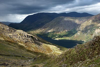
Nat Park - Lake District - Lake District Western Fells
Wainwrights - Dale Head, Haystacks, High Crag, High Stile, Red Pike (Buttermere), Robinson
County/Area - Cumbria
Author - Stephen Starkey
Length - 14.0 miles / 22.8 km Ascent - 5800 feet / 1758 metres
Time - 12 hours 50 minutes Grade - very hard
Walk Route Description
Click image to visit gallery of 3 images.
This is a strenuous Lake District walk that presents no technical difficulties. It starts from the village of Buttermere, which is situated on the shores of the lake with the same name. As with all mountain walks you should ensure that you have adequate clothing and food. Emergency exit points are noted in the description is you need to shorten the route.
The start is the Youth Hostel (Grid ref. NY178168) in Buttermere. Head north along the road to Buttermere village then take the bridleway to the left of The Fish Hotel. At the fork in the bridleway next to the fence, take the left hand fork to Buttermere Dubs footbridge (Grid ref. NY 173163). Cross the footbridge and then take the stone stepped path through Burntness Wood and up to Bleaberry Tarn (Grid ref. NY 166154).
Cross the outlet from the tarn to Sour Milk Gill and continue climbing on the obvious path to The Saddle (Grid ref. NY 163155) where a short detour to the right up a wide grassy path leads to the summit of Dodd (Grid ref. NY 164157) with spectacular views over Crummockwater and Buttermere.
Retrace the route back to The Saddle then continue the climb to the summit of Red Pike (Grid ref. NY 160154). Continue ahead for about 100 metres from the summit to where the main path crosses then turn left to follow the main path along the ridge, taking in High Stile, High Crag and Seat to arrive at the path junction at Scarth Gap. (From here there are escape routes available back to Buttermere lake via either Scarth Gap or Warnscale Beck just beyond Haystacks).
The main route continues from Scarth Gap to take in the twin summits of Haystacks - with all the plaudits from others, this for me is the most disappointing of all the Lakeland Fells. From Haystacks the path descends past Innominate Tarn and Blackbeck Tarn. Masochists may want to detour to take in the spectacular views from Fleetwith Pike. However, for normal, mortal beings, the route heads off to the road at Honister Hause.
The easiest route needs a little care on the navigation, ensuring you go right at the first fork in the path and left at the second fork, after which fording Warnscale Beck can be tricky if in spate, before the route heads around the Eastern slopes of Fleetwith Pike and then drops down to the Honister Pass road (Grid ref. NY 225135). (If required, the road can be used as a downhill escape route back to Buttermere with an occasional bus in season).
For the full route, cross the road and start the long slog up to the summit of Dale Head (Grid ref. NY 223153). At the summit cairn, turn left to follow a ridge path along Hindscarth Edge which provides stunning views on a clear day. At Grid ref. NY 214158 where a path forks right to Hindscarth, take the left hand path to go along Littledale Edge then veer right to the summit of Robinson (Grid ref. NY 202168).
The route back to the Youth Hostel is then reasonably straightforward, traversing rough open moorland of High Snockrigg (which can offer spectacular sunset views over Red Pike et al) before starting out on a knee jarringly steep descent to the Newlands Road just beyond the Youth Hostel
Maps 

| Ordnance Survey Explorer OL4 | Sheet Map | 1:25k | BUY |
| Anquet OS Explorer OL4 | Digital Map | 1:25k | BUY |
| Ordnance Survey Digital Map Subscription | |||
| Latest Ordnance Survey Discounts | |||
Other walks nearby
| Walk 1142 | Buttermere Circular | easy | 4.5 miles |
| Walk 2609 | Grasmoor via Crag Hill | mod/hard | 8.0 miles |
| Walk 2735 | Fleetwith Pike and Buttermere Circular | mod/hard | 8.5 miles |
| Walk 1732 | Coledale and Newlands circular from near Buttermere | hard | 9.0 miles |
| Walk 1011 | Knott Rigg and Ard Crags | easy/mod | 3.5 miles |
| Walk 2539 | Grasmoor and Rannerdale Knotts | moderate | 8.0 miles |
| Walk 1153 | The High Stile Ridge | hard | 10.0 miles |
| Walk 1289 | Fleetwith Pike & Haystacks | moderate | 5.5 miles |
| Walk 1231 | Grasmoor via Whiteless Pike | moderate | 7.0 miles |
| Walk 2020 | Rannerdale Knotts and Crummock Water from Cinderdale Common | easy/mod | 2.5 miles |
Recommended Books & eBooks
Lake District: Low Level and Lake Walks
 This guidebook describes 30 of the best low-level walks in the Lake District. From delightful wooded glades and sparkling tarns, to waterfalls and glacier-carved valleys towered over by craggy mountains. The walks described aim to seek out the best walking that the lower areas of the Lake District have to offer.
More information
Outdoor Adventures with Children - Lake District
 Guidebook to 40 outdoor adventures in the Lake District with children under 12, including walking, cycling, orienteering, paddling, boating, hostelling and more. Graded activities for varying age ranges or for families with children of different ages.
More information
