Walk 1304 - printer friendly version
Plynlimon Walk
Author - Peter Lane
Length - 5.0 miles / 8.1 km
Ascent - 1100 feet / 333 metres
Grade - moderate
Start - OS grid reference SN799841
Lat 52.441629 + Long -3.7683266
Postcode SY23 3LE (approx. location only)
Plynlimon is the highest point in mid-Wales and also the high plateau watershed from which two major rivers: the Severn and the Wye derive their source. A wild and barren place, its desolation belies its relative accessibility. This spectacular walk across barren wilderness affords panoramic views that more than rival Snowdonia (Eryri), with the added bonus that practically nobody will be there to spoil your enjoyment of it. This walk is a serious undertaking suitable only for experienced hill walkers comfortable with finding routes across trackless wilderness. This route should not be attempted in poor visibility due to a lack of defined paths and landmarks on the high plateau. It is also recommended that the 1:25,000 Explorer map be used. The ground in this area can be boggy and treacherous, so poles are recommended for testing the ground ahead. An alternative route is available at Walk 2138.
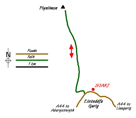
The start point for this walk is in the hamlet of Esteddfa Gurig (grid ref. SN799841). Enter the farmyard at the fingerpost and pass by a cage most likely filled with barking dogs. All the dogs were caged or tethered when I passed by, but be prepared just in case with a stick or pole. A metal gate marked "All Walks" at the time of writing ahead takes you to the side of a stream. Follow this along a well defined path initially going West and then turning North after a short while all the way up to some derelict mine workings.
Just before reaching the mine workings, the path turns off left (watch out for the waymark). The path deteriorates into little more than a sheep track in a very short space of time. Once you get close to the summit, the path becomes more distinct and cairns guide you to the summit of Pumlumon Fawr. A ladder stile crosses the fence and a dry stone walled refuge and trig point populate the summit. The views are truly magnificent and extend 360 degrees. It is worth exploring a little trying to find other viewpoints before returning by the same route to the start.
Messaging & Social Media
Message Walking Britain and follow the latest news.

Mountain Weather
Stay safe on the mountains with detailed weather forecasts - for iOS devices or for Android devices.