Plynlimon Circular from Eisteddfa Gurig
Cambrian Mountains Walk
Region - Cambrian Mountains
County/Area - Ceredigion
Author - Lou Johnson
Length - 5.0 miles / 8.1 km Ascent - 1100 feet / 333 metres
Time - 3 hours 40 minutes Grade - moderate
Walk Route Description
Click image to see photo description.
This Ceredigion walk visits the summit of Plynlimon (752 m.) in the Cambrian Mountains. The area was considered for National Park status with its often-desolate landscape. The route sees few walkers and it is recommended you carry the relevant OS 1:25000 Explorer map as paths and tracks used for the walk are often ill-defined. The lack of landmarks adds to the need for careful navigation. An alternative route is available at Walk 1304.
The start is Eisteddfa-Gurig car park (grid refSN799841) located on the north side of the A44 east of Aberystwyth. After parking turn right up the farm drive through a gate. Ignore the first track on the left and follow the track as it bends left. Soon the track bends right and heads up a valley. Continue up the valley for 1.5 kilometres to reach an old mine. Just before where the tracks swings right across the Afon Tarrenig, bear left onto a path with adjacent marker post (grid ref. SN796858).
Continue uphill following a grassy track which in places is ill-defined. If in doubt keep heading uphill! After a kilometre you reach the summit of Plynlimon with an OS trig column and a rocky, circular shelter. The view is superb covering much of mid-Wales and parts of Snowdonia (Eryri). If time permits, it is worth exploring the summit area to enjoy different views.
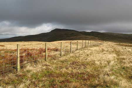
The descent route follows the fence (on your right) south for two kilometres at reach a plantation. The path then continues downhill with the plantation on your right. Reaching a path junction (grid ref. SN786481), turn left and follow a twisting grassy track to pass a large shed (old mine?) on your right. Continue along the track to re-join the outward route. Continue through the yard and turn left back to the car park.
Maps 

| Ordnance Survey Explorer 213 | Sheet Map | 1:25k | BUY |
| Anquet OS Explorer 213 | Digital Map | 1:25k | BUY |
| Ordnance Survey Digital Map Subscription | |||
| Latest Ordnance Survey Discounts | |||
Other walks nearby
| Walk 2048 | Craig-y-Pistyll, Cambrian Mountains | moderate | 10.0 miles |
| Walk 3086 | Pen y Garn from near Devil's Bridge | easy/mod | 6.8 miles |
| Walk 1705 | Bont-goch Circular from near Aberystwyth | easy/mod | 4.5 miles |
| Walk 1898 | Severn Valley from Llanidloes | moderate | 11.3 miles |
| Walk 2736 | Teifi Pools from near Strata Florida | easy/mod | 6.2 miles |
| Walk 1365 | Strata Florida to Tregaron | moderate | 9.5 miles |
| Walk 1420 | Borth to Aberystwyth coast | easy/mod | 6.5 miles |
| Walk 3297 | Crugyn Ci, Esgair Perfedd & Penygarreg - Elan Valley | moderate | 7.5 miles |
| Walk 1363 | The Elephant Walk from Tregaron | easy/mod | 5.5 miles |
| Walk 3317 | Happy Valley Circular | easy | 4.2 miles |
Recommended Books & eBooks
The Wales Coast Path
 A single guidebook to walking the whole Wales Coast Path - 1400km (870 miles) the length of Wales from Chester to Chepstow, including Anglesey, described in 57 stages. The route passes through the Snowdonia and Pembrokeshire National Parks and many AONBs and can be linked with the Offa's Dyke Path for a complete circuit of Wales.
More information
