Ben Nevis Tourist Path from Glen Nevis
Highland Walk
County/Area - Highland - Fort William Lochaber
Author - Peter Smyly
Length - 8.7 miles / 14.1 km Ascent - 4460 feet / 1352 metres
Time - 8 hours 50 minutes Grade - mod/hard
Walk Route Description
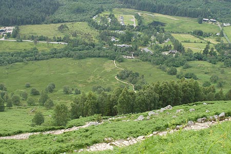
Click image to visit gallery of 8 images.
When it comes to mountains, biggest is not necessarily best, though with its fame as the highest one in the British Isles, Ben Nevis is inevitably the main draw in the Lochaber area, even in cloud and rain. By way of contrast, the other three 4,000 foot plus peaks in the Lochaber area, Carn Mor Dearg, Aonach Mor and Aonach Beag tend to see far fewer walkers.
Although people's opinions and experiences of it vary, it is generally recognised that the walk up and down takes around six to seven hours. Of the two main walking routes up Ben Nevis, this one is by far the busier but easily the less spectacular. The other one is via the dramatic Carn Mor Dearg arête which reveals the 2,300 foot cliffs of "The Ben", a view not seen on this route.
Weather conditions at the summit at a height of 4,409 feet are likely to be very different from the start near to sea level. The average temperature at the summit is around freezing, therefore take extra layers to put on. While the top may be cloud-free at the outset, the summit plateau can easily be in cloud by the time you get up there.
The walk is not technically difficult and, from a route-finding point of view, it is straightforward as you come back down the same way you go up. In good weather conditions, any fit walker should be able to complete it without any real difficulty. The rocky summit plateau of Ben Nevis, however, is often swathed in cloud and the path to the top passes within just a few feet of the biggest cliffs on the UK mainland. Although not seen from the main path, there are also dangerous gullies nearby such as Five Finger Gully, meaning that careful navigation is required. Even on a wet and cloudy day, there may well be plenty of other people walking up and down the main path. Further, the path on the summit plateau is waymarked by a series of cairns.
Start from the Youth Hostel at Glen Nevis and cross the bridge over the river. A notice board on the right warns of the need to be properly prepared if going all the way to the top since this is not a walk to be undertaken lightly or without suitable gear. Follow the route ahead which soon rises by way of a well-constructed path that winds its way up through bracken to meet up with the path coming in from Achintee House. The route to the Half Way Lochan (Lochan Meall an t-Suidhe) takes about an hour and the view to the right on the way up reveals a long cascade or stream coming down green grassy slopes, but higher up above it, grey is very much the colour. At 1960 feet, the lochan is less than half way up. The path elbows left to allow a more direct, but heavily eroded, path a chance to recover, and then to the right. At a T junction of paths a path off to the left leads to the Allt a' Mhuillin valley but this route follows the Tourist Track to the right along the first of the zig zags. The path crosses the Red Burn waterfall, a landmark which breaks up the monotony of the zig zags. Further up, you can sometimes anticipate where the path goes next by spotting a horizontal line of moving figures part way up the rocky slopes above.
Eventually though, with the Half Way Lochan now way below, the zig zags end. There is still more ground to be covered, another half a mile or so across the summit plateau and it may well feel significantly colder by this point. Further, there is a more or less total lack of green vegetation as the mountain slopes are now covered in grey rock, stone and gravel. When I did this walk, the path crossed a sloping snow field as it entered the cloud base and some walkers were using ski poles to cross the snow, giving the scene an almost alpine feel. There were no views other than of the mist-shrouded summit plateau with ghost-like figures of other walkers emerging from and disappearing into the mist. Having come this far, it would seem a pity to turn back though. Chances are you will have company at the top even in poor weather and, even in cloud, it takes little imagination to envisage the massive drop over the edge just a few feet from the summit trig point to the east. Snow cornices tend to adorn the summit plateau edges and these should be severely avoided.
Maps 

| Ordnance Survey Explorer 392 | Sheet Map | 1:25k | BUY |
| Anquet OS Explorer 392 | Digital Map | 1:25k | BUY |
| Ordnance Survey Digital Map Subscription | |||
| Latest Ordnance Survey Discounts | |||
Other walks nearby
| Walk 3270 | Ben Nevis | mod/hard | 9.7 miles |
| Walk 2105 | Ben Nevis via Carn Mor Dearg arete | hard | 10.5 miles |
| Walk 3303 | Mamores Ridge - Stob Ban, Am Bodach and Sgurr an Iubhair | hard | 9.0 miles |
| Walk 3095 | Stob Ban (Mamores) | mod/hard | 6.0 miles |
| Walk 3066 | Carn Mor Dearg (via Allt a' Mhuilinn trail) | mod/hard | 8.7 miles |
| Walk 2918 | Aonach Mor and Aonach Beag - two of the "Lochaber giants" | mod/hard | 9.0 miles |
| Walk 3106 | Binnein Mor from Kinlochleven | hard | 10.2 miles |
| Walk 1039 | Am Bodach and Stob Coire a' Chairn | mod/hard | 9.5 miles |
| Walk 1094 | Blackwater Reservoir | moderate | 11.5 miles |
| Walk 1496 | WHW - Day 6 - Kinlocheven to Fort William | moderate | 15.0 miles |
Recommended Books & eBooks
Walking in Torridon
 This guidebook contains 52 day walks in Torridon, a remote and much-loved area of the Scottish Highlands. Based around Shieldaig and Slioch, the routes are split into 3 sections: easy walks, long and high level walks and mountain ascents over 2000ft including 9 Munros, and 5 outline suggestions for major ridge walks.
More information
Walking the Munros Vol 2 - Northern Highlands and the Cairngorms
 Guidebook to walking the northern Munros, covering the northern Highlands, the Cairngorms and the Isle of Skye. 70 routes are described, including those up Ben Macdui, Braeriach and Cairn Gorm. Routes range from 7 to 46km, requiring a fair level of fitness. The second of two guidebooks to walking Scotland's Munros: peaks higher than 3000ft.
More information
