Ben Nevis from Glen Nevis
Highland Walk
County/Area - Highland - Fort William Lochaber
Author - Lou Johnson
Length - 9.7 miles / 15.8 km Ascent - 4400 feet / 1333 metres
Time - 9 hours 20 minutes Grade - mod/hard
Walk Route Description
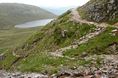
Click image to see photo description.
This walk to the summit of Ben Nevis, Britain's highest mountain, starts from Glen Nevis and follows the tourist path to the summit. The route is a long and relentless climb. The path is good but rocky underfoot so do wear comfortable and durable footwear. Ben Nevis is also subject to rapidly changing weather, so an accurate local forecast is essential. It is worth noting that to avoid snow on the summit the route should not be attempted until the middle of May unless you have appropriate experience and equipment.
The start is the large car park at the Glen Nevis Visitor Centre (grid ref. NN123730). Daily weather forecasts are generally available in the Visitor Centre. Exit the car park at the southern end of the parking area by the toilets and cross the bridge over the River Nevis. Once across the river, turn right and follow the path beside the river for a short way and then turn left on a clear path. You soon enter open country and a path junction (grid ref. NN126728). Go ahead and bear right onto the upper path which climbs steadily up the side of the valley.
After a kilometre you pass a small plantation on your right and the path coming up from Glen Nevis Youth Hostel (grid ref. NN133720). Continue ahead with the path making two zigzags to gain height. The path gets steeper as you climb above Red Burn (down to your right). Another zigzag leads you higher to pass Lochan an t-Suidhe on your left with the bulk of Ben Nevis rising to your right. Reaching a path junction (grid ref. NN147724) turn right and continue uphill soon crossing Red Burn, which marks the half-way point of the ascent.
The route then follows a series of eight zigzags across the western flank of Ben Nevis. Reaching 1200 metres, the path becomes straight and heads for the summit. A final steeper section leads to the summit ridge. In poor visibility, care is needed, and you should follow the line of cairns to the summit. Do not stray too far left as there are the steep crags of Ben Nevis's north face. There is danger on your right too with the steep drops into Five Finger Gully.
After giving yourself a pat on the back and enjoying the view, retrace your steps down the path used for the ascent. Do be careful in descent as you may be tired, and accidents are more likely to happen.
Alternative parking is available in the small car park at Achintree next to the Ben Nevis Inn (grid ref NN125729). If starting from here, head south to gate and adjacent notice board. Continue along the oath and bear left at the first fork to follow the tourist path.
Maps 

| Ordnance Survey Explorer 392 | Sheet Map | 1:25k | BUY |
| Anquet OS Explorer 392 | Digital Map | 1:25k | BUY |
| Ordnance Survey Digital Map Subscription | |||
| Latest Ordnance Survey Discounts | |||
Other walks nearby
| Walk 2105 | Ben Nevis via Carn Mor Dearg arete | hard | 10.5 miles |
| Walk 1338 | Ben Nevis Tourist Path | mod/hard | 8.7 miles |
| Walk 3066 | Carn Mor Dearg (via Allt a' Mhuilinn trail) | mod/hard | 8.7 miles |
| Walk 3303 | Mamores Ridge - Stob Ban, Am Bodach and Sgurr an Iubhair | hard | 9.0 miles |
| Walk 3095 | Stob Ban (Mamores) | mod/hard | 6.0 miles |
| Walk 2918 | Aonach Mor and Aonach Beag - two of the "Lochaber giants" | mod/hard | 9.0 miles |
| Walk 3106 | Binnein Mor from Kinlochleven | hard | 10.2 miles |
| Walk 1039 | Am Bodach and Stob Coire a' Chairn | mod/hard | 9.5 miles |
| Walk 1094 | Blackwater Reservoir | moderate | 11.5 miles |
| Walk 1496 | WHW - Day 6 - Kinlocheven to Fort William | moderate | 15.0 miles |
Recommended Books & eBooks
Great Mountain Days in Scotland
 Inspirational guidebook to 50 challenging routes for mountaineers, scramblers, hillwalkers and fell runners, many long enough to backpack over 2 days, especially in winter (12 to 25 miles). A mix of classic routes and unsung gems across Scotland from Galloway to the Outer Hebrides in widely differing wild landscapes. With customised OS mapping.
More information
Walking in Torridon
 This guidebook contains 52 day walks in Torridon, a remote and much-loved area of the Scottish Highlands. Based around Shieldaig and Slioch, the routes are split into 3 sections: easy walks, long and high level walks and mountain ascents over 2000ft including 9 Munros, and 5 outline suggestions for major ridge walks.
More information
