Walk 1469 - printer friendly version
Carlton Bank, Scugdale, Raisdale & Kirby Bank Walk
Author - Andy Chaplin
Length - 10.5 miles / 17.1 km
Ascent - 1800 feet / 545 metres
Grade - moderate
Start - OS grid reference NZ523030
Lat 54.4197591086 + Long -1.1955228270
Postcode TS9 7JH (approx. location only)
This North York Moors walk has one of the best views on the Cleveland Way. However like all good things in life, it requires some effort which in this case is the climb up Kirby Bank to enjoy it. The route follows a mixture of moorland paths, tracks, quiet country lanes across variety of terrain.
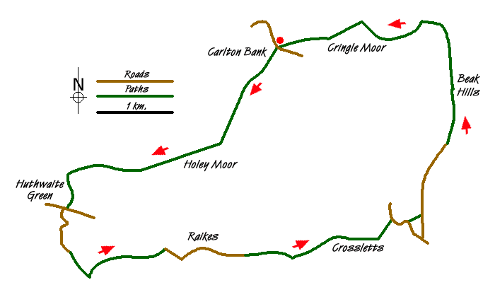
Starting just south of Carlton in Cleveland there are several car parking places where the Cleveland Way crosses the Raisdale Road at grid ref. NZ523030. It is also possible to park in the Lord Stones Country Park where there is café, toilets and bar.
Take the Cleveland Way west signposted to Huthwaite Green and climb uphill on the stone-stepped path onto Carlton Bank. At the trig point at spot height 408 (grid ref. NZ519025) carry straight on keeping the edge of the bank on your left. Carry on down Faceby Bank over Round Hill then down Knoll's End through and then at the side of the Faceby plantation to the road at Huthwaite Green (grid ref. NZ493007).
Take the road leading away opposite the post box and past Holin Hill farm. After the ford over the Scugdale Beck, leave the Cleveland Way, which turns off to the right, and continue along the road to Harfa Bank Farm (grid ref. NZ499900). Turn left on the track that continues past Harfa House then through three gates before crossing the beck again and coming onto the road that leads off on the right up Scugdale past Raikes Farm to Scugdale Hall (grid ref. NZ518000).
Go through the gate after Scugdale Hall then, at the sign that says no vehicles or cycles, branch off left uphill on the track with Barkers Crags on the left and the power lines on your right. The track carries on uphill, passes under the power lines then goes through a gate at the top. As you pass under the power lines again at the junction with another track continue to the left down into the valley.
At the next gate take the bridleway that runs straight ahead at the left of the wall and follow it all the way down through two gates and down Mill Lane, which is a bridleway between walls and hedgerows/fences. At then end turn left on the track that leads through the cottages at Raisdale Mill. At the end of the cottages turn right on the track to go up to the road at High Crosslets Farm.
Turn right on the road (grid ref. NZ539005) before taking the first footpath on the left which goes up the field parallel to the wall and crosses over a stile onto the road that leads up to Cold Moor Cote. After Cold Moor Cote stay on the track towards Beak Hills rather than bearing right on the bridleway. Keep to the right of the farm buildings at Beak Hills (grid ref. NZ547024) and continue up the track towards the Cleveland Way at Broughton Bank.
Turn left and climb up Kirby Bank for probably one of the best views on the Cleveland Way above Dromonby Bank. The orientation table points out the views from Middlesborough (which is pretty obvious) to Cross Fell on the Pennine Way (which must be one of the ones you can see!). Follow the path down past Green Bank to the parking and facilities at Lord Stones.
Messaging & Social Media
Message Walking Britain and follow the latest news.

Mountain Weather
Stay safe on the mountains with detailed weather forecasts - for iOS devices or for Android devices.