Carlton Bank, Scugdale, Raisdale & Kirby Bank
North York Moors Walk
Nat Park - North York Moors - North York Moors West
County/Area - North Yorkshire
Author - Andy Chaplin
Length - 10.5 miles / 17.1 km Ascent - 1800 feet / 545 metres
Time - 7 hours 0 minutes Grade - moderate
Walk Route Description
Click image to see photo description.
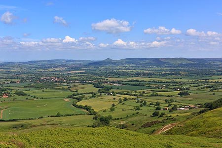
This North York Moors walk has one of the best views on the Cleveland Way. However like all good things in life, it requires some effort which in this case is the climb up Kirby Bank to enjoy it. The route follows a mixture of moorland paths, tracks, quiet country lanes across variety of terrain.
Starting just south of Carlton in Cleveland there are several car parking places where the Cleveland Way crosses the Raisdale Road at grid ref. NZ523030. It is also possible to park in the Lord Stones Country Park where there is café, toilets and bar.
Take the Cleveland Way west signposted to Huthwaite Green and climb uphill on the stone-stepped path onto Carlton Bank. At the trig point at spot height 408 (grid ref. NZ519025) carry straight on keeping the edge of the bank on your left. Carry on down Faceby Bank over Round Hill then down Knoll's End through and then at the side of the Faceby plantation to the road at Huthwaite Green (grid ref. NZ493007).
Take the road leading away opposite the post box and past Holin Hill farm. After the ford over the Scugdale Beck, leave the Cleveland Way, which turns off to the right, and continue along the road to Harfa Bank Farm (grid ref. NZ499900). Turn left on the track that continues past Harfa House then through three gates before crossing the beck again and coming onto the road that leads off on the right up Scugdale past Raikes Farm to Scugdale Hall (grid ref. NZ518000).
Go through the gate after Scugdale Hall then, at the sign that says no vehicles or cycles, branch off left uphill on the track with Barkers Crags on the left and the power lines on your right. The track carries on uphill, passes under the power lines then goes through a gate at the top. As you pass under the power lines again at the junction with another track continue to the left down into the valley.
At the next gate take the bridleway that runs straight ahead at the left of the wall and follow it all the way down through two gates and down Mill Lane, which is a bridleway between walls and hedgerows/fences. At then end turn left on the track that leads through the cottages at Raisdale Mill. At the end of the cottages turn right on the track to go up to the road at High Crosslets Farm.
Turn right on the road (grid ref. NZ539005) before taking the first footpath on the left which goes up the field parallel to the wall and crosses over a stile onto the road that leads up to Cold Moor Cote. After Cold Moor Cote stay on the track towards Beak Hills rather than bearing right on the bridleway. Keep to the right of the farm buildings at Beak Hills (grid ref. NZ547024) and continue up the track towards the Cleveland Way at Broughton Bank.
Turn left and climb up Kirby Bank for probably one of the best views on the Cleveland Way above Dromonby Bank. The orientation table points out the views from Middlesborough (which is pretty obvious) to Cross Fell on the Pennine Way (which must be one of the ones you can see!). Follow the path down past Green Bank to the parking and facilities at Lord Stones.
Maps 

| Ordnance Survey Explorer OL26 | Sheet Map | 1:25k | BUY |
| Anquet OS Explorer OL26 | Digital Map | 1:25k | BUY |
| Ordnance Survey Digital Map Subscription | |||
| Latest Ordnance Survey Discounts | |||
Other walks nearby
| Walk 3418 | Cringle Moor & the Wain Stones | easy/mod | 6.0 miles |
| Walk 1468 | Wain Stones, Bank Foot & Bloworth Crossing | moderate | 14.3 miles |
| Walk 1544 | Chop Gate, Round Hill & Stumps Cross | moderate | 10.1 miles |
| Walk 1473 | Hollin Hill to Square Corner by the Cleveland Way | moderate | 9.5 miles |
| Walk 1497 | High Paradise around Arden Great Moor from Square Corner | moderate | 14.3 miles |
| Walk 3718 | Scarth Wood Moor from Osmotherley | easy/mod | 6.0 miles |
| Walk 1330 | Roseberry Topping & Captain Cook's Monument | easy/mod | 6.5 miles |
| Walk 1467 | Cleveland Way - Roseberry Common to Tidy Brown Hill | moderate | 15.0 miles |
| Walk 3160 | Roseberry Topping and Captain Cook's Monument | easy/mod | 6.3 miles |
| Walk 2930 | Roseberry Topping from Newton under Roseberry | easy | 3.2 miles |
Recommended Books & eBooks
Trail and Fell Running in the Yorkshire Dales
 Guidebook to 40 of the best trail and fell runs in the Yorkshire Dales National Park. Ranging from 5 to 24 miles, the graded runs start from bases such as Ribblehead, Dent, Sedbergh, Malham and Grassington and take in the region's diverse delights, from castles and waterfalls to iconic mountains such as Whernside, Ingleborough and Pen Y Ghent.
More information
The Cleveland Way Map Booklet
 Map booklet of the Cleveland Way National Trail, a 177km (110 mile) walk around the North York Moors National Park. This booklet is included with the Cicerone guidebook to the Cleveland Way and the Yorkshire Wolds Way, and shows the full route of the Cleveland Way on Ordnance Survey 1:25,000 maps.
More information
