Baysdale Circular
North York Moors Walk
Nat Park - North York Moors - North York Moors West
County/Area - North Yorkshire
Author - Andy Chaplin
Length - 9.5 miles / 15.4 km Ascent - 1200 feet / 364 metres
Time - 6 hours 0 minutes Grade - moderate
Walk Route Description
Click image to visit gallery of 3 images.
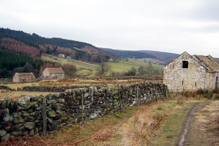
Apart from the holiday cottages at Baysdale Abbey, and a couple of farms in the valley, Baysdale feels remote. There is only the one road in from Kildale, some 4kms away, over Warren Moor which means there is no passing traffic. With great views and well defined tracks, it makes for a good walk.
To start this North York Moors walk park at Hob Hole (grid ref. NZ652075) where there is plenty of off-road space where the road fords Baysdale Beck and then walk north up the road towards the junction with the road from Castleton. Turn off left on the bridleway track that heads westwards above the beck. After a mile and a half you come past a derelict barn and at the signed junction of paths carry straight on westwards along the wall.
After a further half a mile there is a gate where you turn left down towards another derelict barn. Behind you is a stone cairn on Warren Moor. Go past the barn to the bridge over the beck where you pick up the road from Shepherd's House towards Baysdale Abbey. The road follows the beck to the farm and then on to the holiday cottages building. The path is signed through the farm buildings and the gate into the field just to the north of the holiday cottages parking is apparent.
Take the grass track up to the woods - climbing up Middle Head Intake between the Black Beck valley to your right and the Grain Beck valley on your left. There is a short section on the track through the woods then it is a moors track all the way up Middle Head. As you reach the top of the climb two tracks merge from the right, the second one being the Ingleby Coal Road. Keep heading south, on what is now called the Flagged Road Track until you cross the head of the valley at Armouth Wath.
Here there is evidence of old mine buildings and small bridges over the Black Hagg beck. The track bends around back to the north, heading along the east side of the Grain Beck valley before it reaches the top of Baysdale Moor where there are views eastwards down Stock Dale to the Esk valley.
At the next junction with a track turn left, rather than right towards the Shooting Box which is visible on your right. The track bends northwards and starts to descend back towards Baysdale. At the next fork in the track (at grid ref NZ630062) bear right and then follow it to the right as you head towards Great Hograh Beck. Ignore the first track on the right to the beck and take either a steep path off on the right or an easier path a little further on ? both of which lead to a pretty stone bridge built in 1938, according to the keystone, which you cross and then carry on eastwards.
The path here is not too clear at the start, but it goes directly away from the beck and there are a series of stone piles which mark it. As it crosses Great Hograh Moor it becomes well defined and is still marked by a series of stone piles. Come down Little Hograh Moor to the John Breckton Road, follow it to your left then take the road at the junction back down to Hob Hole.
Maps 

| Ordnance Survey Explorer OL26 | Sheet Map | 1:25k | BUY |
| Anquet OS Explorer OL26 | Digital Map | 1:25k | BUY |
| Ordnance Survey Digital Map Subscription | |||
| Latest Ordnance Survey Discounts | |||
Other walks nearby
| Walk 3187 | Esklets and Rosedale Head from Westerdale | moderate | 11.0 miles |
| Walk 2685 | Highcliff Nab and Guisborough Moor | moderate | 11.1 miles |
| Walk 3737 | Commondale & Esk Valley | easy/mod | 8.2 miles |
| Walk 1450 | Little & Great Fryup Dales | moderate | 8.3 miles |
| Walk 1467 | Cleveland Way - Roseberry Common to Tidy Brown Hill | moderate | 15.0 miles |
| Walk 1050 | Highcliff Nab & Roseberry Topping from Slapewath | moderate | 10.5 miles |
| Walk 1330 | Roseberry Topping & Captain Cook's Monument | easy/mod | 6.5 miles |
| Walk 1468 | Wain Stones, Bank Foot & Bloworth Crossing | moderate | 14.3 miles |
| Walk 1527 | Farndale Circular from Little Blakey | moderate | 12.0 miles |
| Walk 1674 | Rosedale Valley circular from Little Blakey | moderate | 11.0 miles |
Recommended Books & eBooks
Trail and Fell Running in the Yorkshire Dales
 Guidebook to 40 of the best trail and fell runs in the Yorkshire Dales National Park. Ranging from 5 to 24 miles, the graded runs start from bases such as Ribblehead, Dent, Sedbergh, Malham and Grassington and take in the region's diverse delights, from castles and waterfalls to iconic mountains such as Whernside, Ingleborough and Pen Y Ghent.
More information
