Cregennen Lakes from Barmouth
Snowdonia/Eryri Walk
Nat Park - Snowdonia - Cadair Idris
County/Area - Gwynedd
Author - Lou Johnson
Length - 11.0 miles / 17.9 km Ascent - 1485 feet / 450 metres
Time - 7 hours 0 minutes Grade - moderate
Walk Route Description
Click image to visit gallery of 15 images.
This great Snowdonia (Eryri) walk is full of interest with wide views of the Mawddach Estuary, a charming walk through woodland with waterfalls beside you, open high level views across to Barmouth, two beautiful lakes, a grand panorama of the Cadair Idris range and pleasant walking on quiet country lanes. Despite some sections of road walking, do not let this put you off as the lanes are gated meaning traffic is very light.
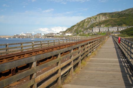
From the start walk towards the sea and follow the promenade with the sea to your right. Continue around the harbour until you reach the main A496 through the town. Turn right and continue along the main road towards the Barmouth Bridge. Cross the road and take the footpath that runs over the bridge. There used to be a toll payable but in 2015 this was no longer the case. Cross the bridge with an excellent view across the Mawddach Estuary to your left.
Reaching the other side of the Mawddach Estuary look out for a stile on your left (grid ref. SH626146). Cross this stile and walk across a raised dyke towards Fegla Fawr (a large rocky outcrop). Turn left along a rough path heading back towards the estuary shoreline. Continue on this path which continues behind a row of houses. At the end of the houses, turn left and locate the continuation of the path running parallel to the estuary.
At the first footpath junction (grid ref. SH633148) turn right and walk inland on a signed bridleway. This leads across open land to reach the Mawddach Trail (grid ref. SH637144). Turn left and continue along the Trail until you reach a small car park on your right (grid ref SH640148). Turn right along the lane, taking a signed footpath on the left. This leads alongside a creek to the main A493 and a small chapel at Arthog. Cross the road with care and take the signed footpath almost opposite up steps into woodland.
The path climbs steadily through the woods with a stream on your left tumbling down many waterfalls and cascades. The path is waymarked and eventually you reach the top of the wood and a picturesque clapper bridge across the stream (grid ref SH649138). Cross the footbridge and follow the signed path across open country with views across the Mawddach Estuary to your left and the rocky hill Cefn-hir ahead. The way ahead is never in doubt until you near the road at grid ref, SH654146). For the final descent to the road keep the wall to your right,
Turn left along the lane and walk uphill past Gefnir Farm until a panorama of the first of the Cregennen Lakes opens up before you. There are many places hereabouts to enjoy a rest and perhaps a picnic.
To continue, walk along the lane around the shores of the lake. The lane continues to climb and a view across the second of the Cregennen Lakes opens up on your left by a large standing stone. On this stretch you can also enjoy a wonderful panorama to your left of the Cadair Idris range. Continue along the lane past the second of the Cgrennen Lakes to reach a road junction (grid ref. SH663135). Turn right and follow this quiet lane past derelict Hafotty-fach to the next junction (grid ref. SH647133).
Turn right here and descend steeply at times, passing close to the clapper bridge. Continue on the lane to a signed bridleway on your left (grid ref SH645139). Follow this bridleway downhill to the main road. Turn right along the main road and take the first signed footpath on your left (grid ref. SH638143). Follow this path to reach the Mawddach Trail where you joined it on the outward route. Turn left along the Trail to Morfa Mawddach station. Do not cross the railway but continue ahead to reach the Barmouth Bridge. All that remains is for you to retrace your steps back to the start.
Maps 

| Ordnance Survey Explorer OL23 | Sheet Map | 1:25k | BUY |
| Anquet OS Explorer OL23 | Digital Map | 1:25k | BUY |
| Ordnance Survey Digital Map Subscription | |||
| Latest Ordnance Survey Discounts | |||
Other walks nearby
| Walk 3229 | Mawddach circular | moderate | 9.0 miles |
| Walk 2450 | Llynnau Cregennen & Mawddach Estuary | moderate | 8.4 miles |
| Walk 1851 | Cregennen Lakes & Pared y Cefn-hir | easy/mod | 2.5 miles |
| Walk 1193 | Y Llethr & Diffwys | mod/hard | 11.5 miles |
| Walk 1746 | Bwlch y Rhiwgyr & Pont Scethin | moderate | 9.8 miles |
| Walk 1172 | Cadair Idris by the Pony Path | mod/hard | 11.0 miles |
| Walk 2668 | Cadair Idris, Craig Cau and Cyfrwy by the Pony Path | mod/hard | 5.3 miles |
| Walk 2570 | Cadair Idris from Llanfihangel-y-pennant | mod/hard | 10.0 miles |
| Walk 2707 | Tyrrau Mawr and Craig-y-llyn from Llanfihangel-y-pennant | moderate | 9.5 miles |
| Walk 1643 | Llanfihangel-y-pennant & Castell y Bere | easy/mod | 6.8 miles |
Recommended Books & eBooks
The Wales Coast Path
 A single guidebook to walking the whole Wales Coast Path - 1400km (870 miles) the length of Wales from Chester to Chepstow, including Anglesey, described in 57 stages. The route passes through the Snowdonia and Pembrokeshire National Parks and many AONBs and can be linked with the Offa's Dyke Path for a complete circuit of Wales.
More information
Snowdonia: 30 Low-level and easy walks - South
 Guidebook describing 30 walks in Snowdonia, Wales. Routes are mostly low level and on clear paths and showcase the region's beautiful scenery and rich history and culture. Part of a 2-volume set, this southern volume includes Trawsfynydd, Bala, Dolgellau, Machynlleth, the Harlech Coast and the valleys of the Mawddach and Dyfi.
More information
