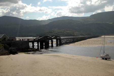
Mawddach Bridge and Arthog from Barmouth
Snowdonia/Eryri Walk
Nat Park - Snowdonia - Cadair Idris
County/Area - Gwynedd
Author - Lou Johnson
Length - 5.4 miles / 8.8 km Ascent - 200 feet / 61 metres
Time - 2 hours 50 minutes Grade - easy
Walk Route Description
Click image to visit gallery of 6 images.
This easy Snowdonia (Eryri) walk offers some fine views of the Mawddach Esturay and the surrounding mountains. Starting from the railway station or main car park in Barmouth (grid ref. SH611158) the route crosses the Barmouth Bridge before exploring the area alongside the estuary near the village of Arthog.
This easy walk offers some fine views of the Mawddach Esturay and the surrounding mountains. Starting from the railway station or main car park in Barmouth (grid ref. SH611158) the route crosses the Barmouth Bridge before exploring the area alongside the estuary near the village of Arthog.
Reaching the other side of the Mawddach Estuary look out for a stile on your left (grid ref. SH626146). Cross this stile and walk across a raised dyke towards Fegla Fawr (a large rocky outcrop). Turn left along a rough path heading back towards the estuary shoreline. Continue on this path which continues behind a row of houses. At the end of the houses, turn left and locate the continuation of the path running parallel to the estuary.
At the first footpath junction (grid ref. SH633148) continue straight ahead towards another large rocky outcrop, Fegla Fach. Reaching a rough track turn sharp right and follow the footpath inland. Reaching another track, turn right. This track some becomes a proper lane which leads to a small car park beside the Mawddach Trail.
Turn right along the Mawddach Trail. This is easy walking and leads you to Morfa Mawddach station. Do not cross the railway but continue ahead to reach the Barmouth Bridge. All that remains is for you to retrace your steps back to the start.
Maps 

| Ordnance Survey Explorer OL23 | Sheet Map | 1:25k | BUY |
| Anquet OS Explorer OL23 | Digital Map | 1:25k | BUY |
| Ordnance Survey Digital Map Subscription | |||
| Latest Ordnance Survey Discounts | |||
Other walks nearby
| Walk 3229 | Mawddach circular | moderate | 9.0 miles |
| Walk 2450 | Llynnau Cregennen & Mawddach Estuary | moderate | 8.4 miles |
| Walk 1851 | Cregennen Lakes & Pared y Cefn-hir | easy/mod | 2.5 miles |
| Walk 1193 | Y Llethr & Diffwys | mod/hard | 11.5 miles |
| Walk 1746 | Bwlch y Rhiwgyr & Pont Scethin | moderate | 9.8 miles |
| Walk 1172 | Cadair Idris by the Pony Path | mod/hard | 11.0 miles |
| Walk 2668 | Cadair Idris, Craig Cau and Cyfrwy by the Pony Path | mod/hard | 5.3 miles |
| Walk 2570 | Cadair Idris from Llanfihangel-y-pennant | mod/hard | 10.0 miles |
| Walk 2707 | Tyrrau Mawr and Craig-y-llyn from Llanfihangel-y-pennant | moderate | 9.5 miles |
| Walk 1643 | Llanfihangel-y-pennant & Castell y Bere | easy/mod | 6.8 miles |
Recommended Books & eBooks
Great Mountain Days in Snowdonia
 Inspirational guidebook to 40 great mountain day walks and scrambles in Snowdonia. Inspirational routes for all abilities across the National Park with routes up Snowdon and Moel Eilio, the Glyderau, the Carneddau, Eifionydd, Siabod and the Moelwynion, Rhinogydd (the Harlech Dome), Migneint and the Arans and Cadair Idris and the Tarrens.
More information
Snowdonia: 30 Low-level and easy walks - South
 Guidebook describing 30 walks in Snowdonia, Wales. Routes are mostly low level and on clear paths and showcase the region's beautiful scenery and rich history and culture. Part of a 2-volume set, this southern volume includes Trawsfynydd, Bala, Dolgellau, Machynlleth, the Harlech Coast and the valleys of the Mawddach and Dyfi.
More information
