Shobdon Hill and Croft Ambrey from Shobdon Estate
Herefordshire Walk
County/Area - Herefordshire
Author - Peter Lane
Length - 12.5 miles / 20.3 km Ascent - 2000 feet / 606 metres
Time - 8 hours 20 minutes Grade - moderate
Walk Route Description
Click image to visit gallery of 12 images.
The North Western part of Herefordshire stands apart from the rural character of the majority of this county and takes on the feel of the Welsh hills less than 10 miles away. The walk makes extensive use of the Mortimer Trail and its subsidiary circular routes. It affords some spectacular views from the lofty vantage points of Shobdon Hill Wood and Croft Ambrey Hill Fort. It also follows the valley of the River Lugg between some impressive wooded hills.
Unfortunately, the walk spans two Explorer maps with no overlap. However, it can be followed readily on the Landranger map paying careful attention to these instructions. The start point for this walk is the Church of St John the Evangelist on the Shobdon Estate (grid ref. SO400628). The Estate is not accessible from Shobdon village, but is approached from a minor road to the East along a tree lined avenue from Easthampton.
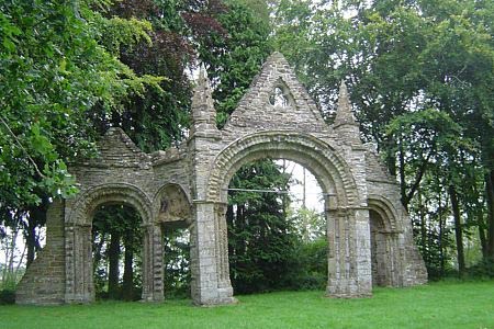
From the church, which is well worth visiting with its Strawberry Hill Gothic architecture> After visiting the church head north up the tree lined avenue to the arches themselves (not the approach road!). When the old church was pulled down, its chancel arch and two doorways, richly carved by sculptors of the Herefordshire School which dominated sculpture in the western counties in the mid-12th century, were removed and reassembled on the hill. They have stood here for almost 250 years.
After admiring the arches, turn left for a very short distance and then right following the Mortimer Trail (Shobdon Loop) markers to a country lane. Turn left along the lane to Uphampton and at the farm buildings on the left, look for a tarmac lane signed as a footpath on the right. This continuation leads to the Forestry Commission compound. Enter the compound through the side gate and walk along the access road, taking the left fork and exiting through another wire gate. After a short distance a broad lane leads off right and directly up the side of Shobdon Hill Wood. Ignore all crossing paths and attain the summit path.
Turn right along the summit path which, when it breaks through the trees, affords some spectacular views, revealing just how high you are. At the end of this all to brief ridge walk, the path descends and curves right towards Covenhope Farm. At the bottom of the hill and through the steel barrier, curve around to the left, continuing along the Mortimer Trail along the flanks of Shobdon Hill Wood. This is another spectacular section of walk, affording some superb views across the valley to Mere Hill Wood. The reason for the tortuous route of the Mortimer Trail becomes obvious on the ground as it is clearly far easier to follow this contour line than to assault all the surrounding hills!
Take care not to miss the descent from the Wood to the road below. The country lane in the valley makes a sudden and obvious 90 degree right turn as it heads across the River Lugg. A partially hidden stile in the hedge leads directly down to the elbow in the road and you continue along the lane and over the Lugg. Having crossed, turn right and follow the flanks of Sned Wood along a footpath that also follows the meandering Lugg. This outstanding valley is nested between rounded, wooded hills of superlative proportions and seems quite out of place in Herefordshire!
The path eventually curves left and leaves the Lugg. After 300 metres a fingerpost directs you across a field and to a country lane at Ballsgate Common. Turn right here and follow the lane to a 90 degree right hand bend where a fingerpost indicates a footpath heading uphill to Sunnybank. Take this path as it becomes more and more overgrown until it broadens again into a green lane. The right of way actually crosses a stile on the left shortly after opening up and follows the lane closely until it heads off to the left slightly, crossing a field at the mid point into another field and eventually to the main A4110 at a cross roads with a minor road heading East to Yatton.
Head up the minor road to Yatton and maintain the Easterly trend at the village hall heading up the footpath towards the hill ahead which is our next objective: Croft Ambrey. The footpath becomes smaller and then just a right of way adjacent to a field as it climbs steadily to a peculiar little house. Here it enters a lane which heads past the house, uphill to a stile and another footpath heading off left. Ignore this, continue with a full frontal attack on the hill which soon sports a Mortimer Trail waymark and ascends directly to Croft Ambrey Hill Fort and a park bench with a view to die for.
Slightly to the left of the bench is an access to the Hill Fort itself. Cross the fence and follow the path through the heather. As the path opens up the summit of the fort with its ramparts and ditches becomes plain. This is one very large and fine example of an ancient hill fort and well worth the short detour to see, notwithstanding the fact that it is the highest point on the route at over 300m. The path descends to a stile at the bottom. Turn left here and retrace to the park bench with a view. Now continue down a muddy section of path along the Mortimer Trail to the crest of Yatton Hill.
Here the waymarking (or my route finding) goes awry. The Mortimer trail follows the crest of Yatton hill, but this (I was informed) is a very overgrown part of the route. In any event, I went past the official Mortimer Trail to a broad green lane that turns right just before a Croft Castle sign board. This lane through Ladyacre Plantation meets up with a hardcore lane some 800 metres later where you turn right to resume the Mortimer Trail. This lane gradually turns South and emerges at a country lane and at a cross-roads on the B4362 where you proceed straight over into Lucton. Just before the road takes a 90 degree left turn, turn right on a footpath that follows the hedge line to the left all the way through fields with good old Herefordshire livestock and farm smells!
The path opens up into the final field with the River Lugg ahead and the main road at Mortimer's Cross on the right. Now the final section of the route unfortunately follows the main B4362 to the second minor road on the right to Easthampton and the Shobdon Estate access road. Take care along the busy B road. Every effort was made to avoid a long road section in this walk, but it was not possible to link the main attractions without a significant extension to the distance.
Maps 

| Ordnance Survey Explorer 201 | Sheet Map | 1:25k | BUY |
| Anquet OS Explorer 201 | Digital Map | 1:25k | BUY |
| Ordnance Survey Explorer 203 | Sheet Map | 1:25k | BUY |
| Anquet OS Explorer 203 | Digital Map | 1:25k | BUY |
| Ordnance Survey Digital Map Subscription | |||
| Latest Ordnance Survey Discounts | |||
Other walks nearby
| Walk 1787 | Pembridge, Eardisland & the Arrow Valley | easy/mod | 7.4 miles |
| Walk 1998 | Harley's Mountain from Lingen | easy/mod | 7.5 miles |
| Walk 3014 | Leominster Circular | easy | 5.0 miles |
| Walk 3285 | The Hergest Ridge and Huntington from Kington | moderate | 12.0 miles |
| Walk 3300 | The Hergest Ridge from Kington | moderate | 8.5 miles |
| Walk 3614 | Herrock Hill from Kington | moderate | 8.0 miles |
| Walk 2840 | High Vinnals & Richard's Castle | easy/mod | 6.0 miles |
| Walk 3221 | High Vinnalls, Burrington, & Richard's Castle | mod/hard | 11.0 miles |
| Walk 3643 | LLan-fawr & Lugg Valley from Whitton | moderate | 7.5 miles |
| Walk 2816 | Kinsley Wood, Stowe and Offa's Dyke | moderate | 12.0 miles |
