Leominster Circular
Herefordshire Walk
County/Area - Herefordshire
Author - Allan Friswell
Length - 5.0 miles / 8.1 km Ascent - 200 feet / 61 metres
Time - 2 hours 40 minutes Grade - easy
Walk Route Description
Click image to visit gallery of 4 images.
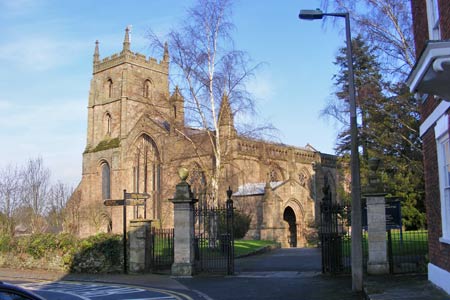
This walk starts in the regional town located on the west side of the River Lugg. The route follows road and riverside paths and provides the opportunity to visit the beautiful red sandstone church which the author rates as un-missable. Parking is available either with the permission of the landlord in the White Lion, or in an adjacent street, or you can even come by train. The town is a charming place to browse on a sunny day, steeped in history and boasting, in the Priory, one of the most astonishing of churches.
The Walk - From the White Lion near the station (Grid ref. SO502588) walk north along Worcester Road with the railway on your right, then along Etnam Street. Then left along High Street, first right along Westbury Street, and left into Ryelands Road. Take the third road on the right (Newland Road) and then the first left into Stockenhill Road. Where the road bends right at number 44, take the footpath between the hedge and fence. At Orchard Lane turn right by the entrance to the bungalow down the narrow path. Cross the awkward iron stile.
Head down the meadow, passing the houses on your left. Cross the stile (grid ref SO485582) and turn right along Ivington Road. Shortly before the houses at the top of the hill turn left at the footpath sign. The track soon becomes quite rutted. At the gate take the stile on the left (SO 480575). Walk uphill then down to the right hand corner, passing the solitary tree on your right. Go over the footbridge (Grid ref SO488573). Then, passing the arched bridge, follow the river Arrow on your right, passing through a gate and then a second gate as you move away from the river (grid ref. SO492572). Then keep to the right of the large field as far as the house on the main Hereford road.
Turn right along the road. When you reach Broadward Hall cross with care, and turn along the farm track passing Broadward Lodge and various barns. This long track eventually crosses a dyke. Here you turn left via a double gate (signed). Keep the hedge on your left as you walk down to the stile which leads you across the railway tracks. Cross with great care! After the kissing gate cross the A49 Leominster Road, and drop down the signed steps to a second kissing gate. Cross the field veering slightly left to the bank of the river Lugg which you follow to the stone bridge and weir of Eaton Hall Farm (grid ref. SO508579). Follow the hedge away from the river to the stile, then make for the football pitch ahead and exit on to the A44. Turn right and cross Eaton Bridge over the Lugg. Take the footpath left at the bridge's end on to the river bank. Keep the river on your left and walk to the field's end where you cross stiles and a plank bridge. Still following the river you pass under the bypass road, and shortly turn left over the bridge. Cross the railway bridge and you are back at your start point.
The Church - The beautiful red sandstone church as seen today is all that remains of the 12th century Benedictine monastery. Following the Dissolution, the Lady Chapel, the east end of the priory church, and the transepts were all destroyed, together with most of the monastic buildings. Essentially the church now consists of three parallel naves, and an additional aisle that makes the building almost as wide as it is long. Short, sturdy cylindrical columns punctuate the north arcade, with triforium and clerestory above. An original feast of Norman simplicity. In complete contrast, the south aisle is a wonderful combination of fine Decorated and elegant Perpendicular work, completed during late 13th/early 14th centuries. A section of arcade between the nave and the south aisle had to be rebuilt after being seriously damaged by fire in 1699. This was again altered at the time of the great Victorian restoration under Sir Gilbert Scott. Un-missable!
Maps 

| Ordnance Survey Explorer 202 | Sheet Map | 1:25k | BUY |
| Anquet OS Explorer 202 | Digital Map | 1:25k | BUY |
| Ordnance Survey Digital Map Subscription | |||
| Latest Ordnance Survey Discounts | |||
Other walks nearby
| Walk 1673 | Shobdon Hill and Croft Ambrey from Shobdon Estate | moderate | 12.5 miles |
| Walk 1787 | Pembridge, Eardisland & the Arrow Valley | easy/mod | 7.4 miles |
| Walk 2840 | High Vinnals & Richard's Castle | easy/mod | 6.0 miles |
| Walk 3221 | High Vinnalls, Burrington, & Richard's Castle | mod/hard | 11.0 miles |
| Walk 3442 | Haws Hill from Tenbury Wells | easy/mod | 6.6 miles |
| Walk 2601 | Marden & Sutton St.Nicholas from Moreton-on-Lugg | easy/mod | 7.5 miles |
| Walk 3104 | Tillington from Moreton on Lugg | easy/mod | 7.5 miles |
| Walk 1998 | Harley's Mountain from Lingen | easy/mod | 7.5 miles |
| Walk 2654 | Titterstone Clee Hill & Cleeton St. Mary from Cleehill | moderate | 7.5 miles |
| Walk 1516 | Pershore Circular | easy/mod | 8.3 miles |
