Walk 1704 - printer friendly version
Oswaldkirk, Nunnington & Harome circular Walk
Author - Andy Chaplin
Length - 11.5 miles / 18.7 km
Ascent - 600 feet / 182 metres
Grade - moderate
Start - OS grid reference SE622790
Lat 54.2029850 + Long -1.0479673
Postcode YO62 5YJ (approx. location only)
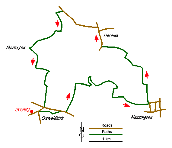
So some walks are determined by where you want to start from and end up at. The Malt Shovel at Oswaldkirk has that rare combination of great view, interesting building, cheap beer (Sam Smiths) and being situated (literally) just the other side of the road from the North York Moors national park.
The walk takes in the villages of Oswaldkirk, Nunnington and Harome where, if you don't know them already, you can wander around the villages. It also takes in the rivers Rye and Riccal, for train enthusiasts there are sections of the old Helmsley-Gilling railway and long distance path "tickers" get just over 3 miles of the Ebor Way.
You can normally park on the road to Ampleforth alongside the Malt Shovel pub. From here walk back to the main road and take the minor road across and to your right past the Old School House. After 500 metres a path angles off to the left to Leysthorpe Lane. Go right on the road and take the first path off on the left. In 2015 the stiles here were not particularly well-kept, but were passable.
Before Seamer Great Wood you follow the path to the right then look hard for the bridge over the White Beck in the corner to your left - again, it was overgrown in summer 2015. Follow the beck eastwards to the River Rye and then either cross at the ford or go upstream and take the footbridge.
The path follows the river then passes under the old Helmsley to Gilling railway before moving away from the river and passing through another well camouflaged stile. Cross the field towards the footbridge, go back over the Rye and come back around Plump Wood. At the southern end of the wood a sign points you towards Nunnington - three quarters of a mile away.
Follow the path along the south bank of the Rye into Nunnington and turn immediately right, back over the river. The path is a farm track which you leave just before Crow Wood then follow the path across fields towards Crook House Farm. Take paths south and west of the farm to pick up the path alongside the River Riccal and continue on to Aby Green Farm.
Take the road into Harome and at the bend near the church and hotel take the path along the Riccal again. When you come out on Acres Lane turn left and after 1km take the bridleway down to the railway. There was no sign on this in 2015 so it may be worth counting off the 3 fields as you walk along Acres lane before looking for the bridleway gate.
Go under the railway bridge and then follow the Ebor Way. It is reasonably well signed as it makes its way past the fish farm, over the Rye again, past Low Parks Farm and on towards Sproxton Hall. Here the path turns back on itself and follows a road towards Throstles Nest. There is a bench amongst the trees half way along the road.
Watch out for the sign off to the right where the path follows the edge of Green Sykes before dog-legging around Belt Plantation and Seamer Little Wood. From here it is south to Oswaldkirk Bank Top, cross the road, take the first path off on the left and come back into Oswaldkirk above the cliff and then on the road past the Old School House again.
Messaging & Social Media
Message Walking Britain and follow the latest news.

Mountain Weather
Stay safe on the mountains with detailed weather forecasts - for iOS devices or for Android devices.