Dufton Pike & Dufton from Knock
North Pennines Walk
Region - North Pennines
County/Area - Cumbria - North Pennines
Author - Lou Johnson
Length - 5.0 miles / 8.1 km Ascent - 500 feet / 152 metres
Time - 3 hours 0 minutes Grade - easy
Maps 

| Ordnance Survey Explorer OL19 | Sheet Map | 1:25k | BUY |
| Anquet OS Explorer OL19 | Digital Map | 1:25k | BUY |
| Ordnance Survey Landranger 91 | Sheet Map | 1:50k | BUY |
| Anquet OS Landranger 91 | Digital Map | 1:50k | BUY |
Walk Route Description
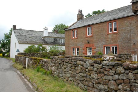
Click image to visit gallery of 12 images.
This low level walk offers a pleasant half day excursion into the country surrounding Dufton Pike. It also offers the chance to visit the pleasant village of Dufton with its pretty cottages lining the village green. Also during the season refreshments are available in the village.
The start is the village of Knock (grid ref NY681269) where there are ample opportunities to park along the main street through the village. However do be considerate and ensure you do not inconvenience residents with reckless parking. After parking, walk to the eastern end of the village to where the road turns sharp right (grid ref NY681269). Here go left up a gravel track which is signed as a public footpath passing Town End Farm on your right. Continue along this track for about 400 metres to just past the point where the track doglegs right and then left.
You will find a signed footpath and a stile on your right. Take this stile and continue across fields walking parallel to Knock Gill which is below on your right. The path descends to gross another stream and then continues above the stream on your right which is now Great Runsdale Beck. If in doubt about the line of the footpath continue walking fairly close to the stream but remain above it in the field. On this section the views are excellent are about to improve again as you continue.
The path eventually comes to a stile in a stone wall (grid ref. NY692273). Cross the stile. You are now on the Pennine Way. Turn right and cross Great Runsdale Beck and once across the river bear left on a clear path. The slopes of Dufton Pike rise quite steeply on your right as you head roughly south-east. Continue through two gates to reach a junction of paths (grid ref. NY703268). Do not follow the signed path up a steep slope; instead stay on the main track which after passing through a gate joins another track (grid ref. NY704267).
Turn right down the track and follow gently downhill towards the village of Dufton. After some way and only just before the village of Dufton you reach a footpath sign on the right. This is the Pennine Way. If you want to visit Dufton village continue straight ahead and return to this point to continue.
Turning right down the Pennine Way (grid ref. NY691252) you follow an enclosed path at first which soon opens out as it passes through pastures. This was once a track but lack of use through the years has reduced the route to a narrower footpath. After about 500 metres the path joins a track coming in from the left. Bear right and follow the continuation of the Pennine Way. After another 200 metres the track divides. The Pennine Way bears right but you need to bear left and follow a slightly overgrown enclosed path.
This path leads you to Dufton Church (grid ref. NY684261), which lies in an isolated distance some way from the village. Go through the main gate and walk to the back of the church and through the gate in the wall to locate a footpath across fields heading roughly north. After crossing a field the path turns sharp left over a footbridge which then leads along the side of a field to reach a tarmac lane (grid ref. NY682264). Turn right along the lane and you are soon back in the village of Knock.
Other walks nearby
| Walk 1339 | High Cup Nick | moderate | 10.5 miles |
| Walk 3011 | Dufton Pike | easy/mod | 5.5 miles |
| Walk 3070 | Knock Fell & High Cup Nick | mod/hard | 12.0 miles |
| Walk 3421 | High Cup Nick via Middle Tongue | moderate | 9.3 miles |
| Walk 3071 | Cross Fell & Great Dun Fell from Kirkland | mod/hard | 12.0 miles |
| Walk 1784 | Rutter Force & Hoff Beck | easy/mod | 8.0 miles |
| Walk 3274 | Cronkley Scar & Cauldron Snout | moderate | 8.0 miles |
| Walk 1683 | High Cup Nick & Cow Green Reservoir | moderate | 12.8 miles |
| Walk 3336 | Cauldron Snout | easy | 3.6 miles |
| Walk 3593 | Meldon Hill from Cow Green Reservoir | moderate | 9.2 miles |
Recommended Books & eBooks
The Pennine Way - the Path, the People, the Journey
 A portrait of the The Pennine Way, Britain's oldest and best known long-distance footpath, stretching 268 miles from the Peak District to the Scottish Borders. This personal, thoughtful and often humorous story of the path's remarkable history, includes the experiences of walkers and local characters on this exhilarating and complex path.
More information
Great Mountain Days in the Pennines
 An inspirational guidebook to 50 classic walks on the rolling Pennine landscape. The graded routes, between 6 and 13 miles in length, cover classic Pennine fells and moorland such as Whernside, Ilkley Moor and Pendle Hill; exploring the North and South Pennines, Yorkshire Dales, Howgills and Dark Peak. Many routes are also suited to fell running.
More information
Messaging & Social Media
Message Walking Britain and follow the latest news.

Mountain Weather
Stay safe on the mountains with detailed weather forecasts - for iOS devices or for Android devices.