Rutter Force & Hoff Beck from Appleby
Cumbria Walk
County/Area - Cumbria - North Cumbria
Author - Lou Johnson
Length - 8.0 miles / 13 km Ascent - 600 feet / 182 metres
Time - 4 hours 40 minutes Grade - easy/mod
Walk Route Description
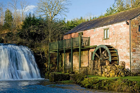
Click image to see photo description.
Starting from Appleby in Westmorland this walk explores the landscape, the River Eden and Hoff Beck which lie to the south of this attractive market town. The route follows the Pennine Journey long distance trail alongside the River Eden for the outward leg. Reaching the village of Great Ormside, the route turns west to visit the pretty Rutter Force and adjacent mill on Hoff Beck. The return to Appleby follows the Dales High Way which follows Hoff Beck for part of the way.
The start is the Broad Close car park (Grid ref. NY682203). After parking, exit the car park and turn right along Chapel Street. At the first junction turn left into Holme Street and almost immediately right into Doomgate. Continue to the B6260 where you keep ahead. Skirt the Castle on your left and when the B6260 bends right, turn left down Castle Bank (grid ref. NY686198). At the bottom of the lane, turn right through a kissing gate (signed to Ormside).
You are now following the Pennine Journey trail which follows the River Eden south. The path crosses several stiles and passes through pleasant woodland. Eventually the path bears right up steps to leave the river. After a short ascent bear left with a fence on your right. The route descends to cross footbridge (grid ref. NY695175). A short climb leads to a stile. Go half left to reach a track where you turn left. The track soon bends right under a railway and continues to Great Ormside (grid ref. NY701173).
Turn right and follow the lane under a railway bridge. Continue ahead at the next junction, pass a caravan site on your left. Go straight across the crossroads (grid ref. NY692164) and continue uphill to Porch Cottage on your left. Turn right over the stile opposite (signed Broadmire Road). Go half left to a stile and then continue along the left-hand edge of a field to reach Broadmire Road. Turn left and at the next junction turn right to Rutter Falls. Cross the bridge with Rutter Force to your left. Bear right past the cottages and then bear right off the lane (signed to Hoff).
You are now following the Dales High Way. You soon cross to the north bank of Hoff Beck which is closely followed through pastures. The path crosses the Beck and shortly after reaches a lane (grid ref. NY676173). Turn right and continue to the B6260 at Hoff. Go straight cross to follow a farm track. Fork right to a gate. The path then continues through fields with Hoff Beck on your right. After 1.5 km you reach Bandley Bridge.
Cross the bridge, pass through a gate and exit the small wood by another gate. Continue ahead on a rising path. Descend slightly into a hollow and continue to a gate. Once over the brow of the hill bear half left to a gate to join a track descending gently to Colby Lane on the outskirts of Appleby. Turn right and follow the lane to reach the B6260. Turn left and retrace your outward route back to the start.
Maps 

| Ordnance Survey Explorer OL19 | Sheet Map | 1:25k | BUY |
| Anquet OS Explorer OL19 | Digital Map | 1:25k | BUY |
| Ordnance Survey Digital Map Subscription | |||
| Latest Ordnance Survey Discounts | |||
Other walks nearby
| Walk 1339 | High Cup Nick | moderate | 10.5 miles |
| Walk 3011 | Dufton Pike | easy/mod | 5.5 miles |
| Walk 3070 | Knock Fell & High Cup Nick | mod/hard | 12.0 miles |
| Walk 3421 | High Cup Nick via Middle Tongue | moderate | 9.3 miles |
| Walk 1715 | Dufton Pike & Dufton | easy | 5.0 miles |
| Walk 3071 | Cross Fell & Great Dun Fell from Kirkland | mod/hard | 12.0 miles |
| Walk 1388 | Kirkby Stephen & Hartley Circular | easy/mod | 5.0 miles |
| Walk 2538 | Nateby & Waitby Common from Kirkby Stephen | easy/mod | 6.2 miles |
| Walk 1616 | Bowderdale and the Calf | moderate | 10.0 miles |
| Walk 2453 | Askham Fell from Lowther Castle | easy/mod | 7.4 miles |
Recommended Books & eBooks
Hadrian's Wall Path
 Hadrians Wall Path guidebook to walk the 84 mile National Trail. Described in both directions, the main description is west to east between Bowness-on-Solway and Wallsend, Newcastle, with extensions to Maryport and South Shields. With extensive historical information related to this World Heritage site and separate 1:25,000 OS map booklet included.
More information
The Cumbria Way
 A guidebook to the 73 mile Cumbria Way, an easy long-distance walk though the heart of the Lake District National Park, from Ulverston in the south to Carlisle in the north, with good transport links to either end. The route is largely low-level but this guide offers alternative mountain days to climb some of the famous fells en route.
More information
