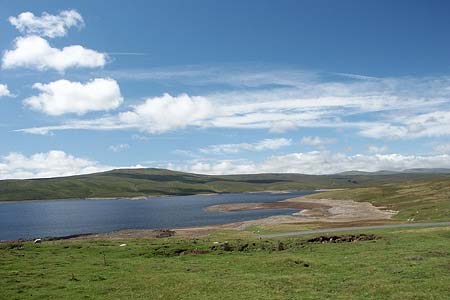
Cronkley Scar & Cauldron Snout from Cow Green
North Pennines Walk
Region - North Pennines
County/Area - Durham
Author - Lou Johnson
Length - 8.0 miles / 13 km Ascent - 800 feet / 242 metres
Time - 4 hours 50 minutes Grade - moderate
Walk Route Description
Click image to visit gallery of 12 images.
The River Tees above Middleton-in-Teesdale offers walkers many interesting distractions including three waterfalls of note. This route visits one of these and covering a section of the Pennine Way also traverses some wonderful riverside scenery. Today the scene is one of tranquillity and beauty yet once the area covered by this walk was the centre of a major controversy when the construction of Cow Green Reservoir was planned for an area with unique flora. As might be expected, the flowers lost out to Government bureaucrats yet with many hours of hard work volunteers saved many of the plants by moving them to a new location.
The start of the walk is the car park at Cow Green Reservoir (Grid ref. NY810309). The car park is signed off the B6277 at Langdon Beck. The car park offers superb views to Cross Fell, Great and Little Dun Fells, Meldon Hill and Mickle Fell amongst others and these North Pennine peaks set the scene for the walk. From the car park you retrace your steps by following the access road you have just used for about 4 km (2.5 miles) to reach a footpath and bridleway post on your right at grid reference NY846309. Go through the gate and bear half left to follow the bridleway sign. At the first field corner, reached after 200 metres, do not go into the field but keep right and aim for a pair of large gates in the wall ahead. Go through the right hand gate (or the hole in the wall to its right) and continue across the field towards Sayer Hill Farm. The footpath passes to the left of this building where you join the Pennine Way (Grid ref. NY852302).
Turn right onto the Pennine Way, which will be followed almost all the way back to Cow Green Reservoir. This National Trail is well way marked and easy to follow. The first section crosses pastures with a view of Cronkley Scar across the River Tees on your left. Soon the path reaches the River Tees and stays with it by-passing Widdy Bank Farm to enter a gorge. At times the path is strewn with boulders and some nimble footwork is required. The immediate surroundings are superb and with crag topped scars and the River Tees you can be forgiven for taking your time through this wonderful setting. The character of the path remains interesting until just past the point where Maize Beck joins the Tees and you are dramatically presented with the roaring waters of Cauldron Snout (Grid ref. NY814286). Today the flow is controlled by engineers but it still remains a superb sight.
The path continues up the right hand side of the waterfall with some easy scrambling required to gain the top. A little further upstream is a bridge (which carries the Pennine Way to Cauldron Snout) and the dam wall of Cow Green Reservoir. To continue turn right onto the clear track and walk up past the right end of the dam wall. The track continues for just over a kilometre to reach a junction (Grid ref. NY815306). Turn left here and after a short way right onto a footpath. This leads you back to the start of the walk.
Maps 

| Ordnance Survey Explorer OL31 | Sheet Map | 1:25k | BUY |
| Anquet OS Explorer OL31 | Digital Map | 1:25k | BUY |
| Ordnance Survey Digital Map Subscription | |||
| Latest Ordnance Survey Discounts | |||
Other walks nearby
| Walk 3424 | Cronkley Fell | easy/mod | 7.0 miles |
| Walk 3526 | Hanging Shaw, Cronkley Scar, Low Force & High Force | moderate | 12.7 miles |
| Walk 1659 | Race Head & Sedling Rake from Wearhead | easy/mod | 6.0 miles |
| Walk 3099 | High Force, Low Force and the River Tees | easy/mod | 7.5 miles |
| Walk 3758 | Tynehead and Ashgill Force from near Garrigill | easy/mod | 8.2 miles |
| Walk 2393 | Weardale Circular from Westgate | easy/mod | 6.4 miles |
| Walk 1084 | Garrigill, Alston & Nenthead | moderate | 13.1 miles |
| Walk 1339 | High Cup Nick | moderate | 10.5 miles |
| Walk 3011 | Dufton Pike | easy/mod | 5.5 miles |
| Walk 3070 | Knock Fell & High Cup Nick | mod/hard | 12.0 miles |
Recommended Books & eBooks
The Pennine Way - the Path, the People, the Journey
 A portrait of the The Pennine Way, Britain's oldest and best known long-distance footpath, stretching 268 miles from the Peak District to the Scottish Borders. This personal, thoughtful and often humorous story of the path's remarkable history, includes the experiences of walkers and local characters on this exhilarating and complex path.
More information
The Pennine Way
 Guidebook to the Pennine Way National Trail with OS map booklet. The 265 mile route from Edale to Kirk Yetholm takes three weeks to walk and is suitable for fit and experienced long distance walkers. The route crosses the Peak District, Yorkshire Dales and North Pennines National Parks. Includes separate OS 1:25,000 map booklet of the route.
More information
