Walk 1718 - printer friendly version
Mull of Galloway circular Walk
Author - Lou Johnson
Length - 6.0 miles / 9.8 km
Ascent - 500 feet / 152 metres
Grade - easy
Start - OS grid reference NX154304
Lat 54.6348550 + Long -4.8617052
Postcode DG9 9HP (approx. location only)
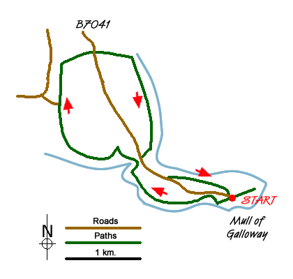
The Mull of Galloway is the southernmost point of Scotland. There is a lighthouse is built in 1830 by engineer Robert Stevenson. The area is a nature reserve managed by the RSPB. The walk follows the south facing cliffs before crossing the peninsula to return along the east coast. As with many coastal walks, expect to encounter some short ascents during the walk.
The start is the small car park close to the lighthouse (grid ref. NX154304). From the parking area follow the coast path west (with the sea to your left) and continue along the cliffs to reach the access road to the peninsula. Here bear left towards West Cairngaan and continue along the coast for about three quarters of a mile before turning inland towards West Cairgaan. There is a waymark at the junction.
Heading north follow the clear path passing West Cairngaan on your left until you near East Cairngaan Farm (grid ref. NX130323) also on your left. Turn right here (east) and follow the path alongside a burn at first to reach a road (grid ref. NX135325). Cross the road and continue east along the banks of Kirk Burn to reach the coast. Turn right along the coast path and walk south towards to the Mull of Galloway.
Returning to the road, bear left and either follow the road back to the start or take the path on your left which offers better views of the cliffs and sea.
Messaging & Social Media
Message Walking Britain and follow the latest news.

Mountain Weather
Stay safe on the mountains with detailed weather forecasts - for iOS devices or for Android devices.